List of populated places in the Caribbean
This is a list of populated places in the Caribbean. Only the major metropolitan areas and largest populated or significant places in each country, national region/district, or national territory are listed. In most cases, the largest populated place for a given country, national region, or territory is the capital.
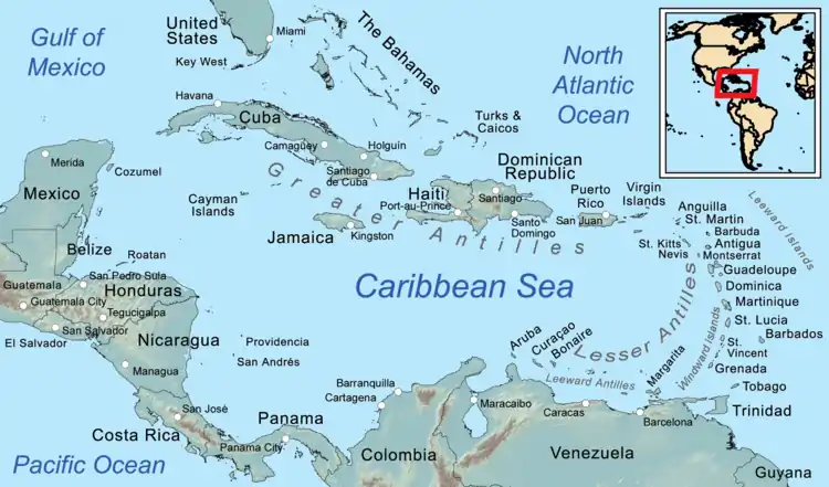
The Caribbean region
Largest populated places
| Link to list of cities by country, region, or territory | Populated place | Population | Year | Refs |
|---|---|---|---|---|
| Anguilla (British Overseas Territory) | The Valley | 2,035 | 2010 | [1] |
| Antigua and Barbuda (Commonwealth realm) | Saint John's | 24,226 | 2010 | [2] |
| Aruba (Constituent state of the Kingdom of the Netherlands) | Oranjestad | 29,998 | 2010 | [3] |
| Bahamas (Commonwealth Realm) | Nassau | 227,940 | 2010 | [4] |
| Barbados | Bridgetown | 98,511 | 2010 | [5] |
| Belize (Commonwealth Realm) | Belize City[Note 1] | 61,461 | 2010 | [6] |
| Bonaire (special municipality of the Netherlands) | Kralendijk | 10,620 | 2017 | [7] |
| British Virgin Islands (British Overseas Territory) | Road Town | 8,449 | 2010 | [8] |
| Cayman Islands (British Overseas Territory) | George Town[Note 2] | 40,200 | 2019 | [9][10] |
| Cuba | Havana | 2,117,625 | 2015 | [11] |
| Curaçao (Constituent state of the Kingdom of the Netherlands) | Willemstad | 136,660 | 2011 | [12] |
| Dominica | Roseau | 14,725 | 2011 | [13] |
| Dominican Republic | Santo Domingo | 3,658,648 | 2015 | [14] |
| Grenada (Commonwealth Realm) | St. George's | 33,734 | 2012 | [15] |
| Guadeloupe (overseas department/region and single territorial collectivity of France) | Pointe-à-Pitre | 132,884 | 2013 | [16] |
| Haiti | Port-au-Prince | 2,618,894 | 2015 | [17] |
| Jamaica (Commonwealth Realm) | Kingston | 1,190,763 | 2015 | [18][19] |
| Martinique (overseas department/region and single territorial collectivity of France) | Fort-de-France | 78,126 | 2013 | [20] |
| Montserrat (British Overseas Territory) | Brades | 1,000 | 1998 | [21] |
| Nueva Esparta (a Venezuelan state) | Porlamar[Note 1] | 144,830 | 2011 | [22] |
| Puerto Rico (Territory of the United States) | San Juan metropolitan area | 2,196,538 | 2015 | [23] |
| Saba (special municipality of the Netherlands) | The Bottom | 462 | 2001 | [24] |
| San Andrés and Providencia (Venezuelan state) | San Andrés[Note 1] | 55,426 | 2005 | [25] |
| Saint Barthélemy (Dependent Territory of France) | Gustavia | 2,300 | 2017 | [26] |
| Saint Kitts and Nevis (Commonwealth Realm) | Basseterre | 14,000 | 2018 | [27] |
| Saint Lucia (Commonwealth Realm) | Castries | 20,000 | 2010 | [28] |
| Saint Martin (Dependent Territory of France) | Marigot | 5,700 | 2006 | [29] |
| Saint Vincent and the Grenadines (Commonwealth Realm) | Kingstown | 12,909 | 2012 | [30] |
| Sint Maarten (Constituent state of the Kingdom of the Netherlands) | Philipsburg | 1,894 | 2017 | [31] |
| Sint Eustatius (special municipality of the Netherlands) | Oranjestad | 1,038 | 2001 | [32] |
| Trinidad and Tobago | Chaguanas[Note 1] | 83,489 | 2011 | [33] |
| Turks and Caicos Islands (British Overseas Territory) | Providenciales[Note 1] | 23,769 | 2012 | [34] |
| United States Virgin Islands (Territory of the United States) | Charlotte Amalie | 18,481 | 2010 | [35][36] |
Notes:
- Not the capital of the country
- George Town is the largest city by population of the British Overseas Territories
Map of places
Cities in other nearby countries
See also
References
- "The Valley". GeoNames. Retrieved September 13, 2021.
- "St. John's". GeoNames. Retrieved September 13, 2021.
- "Oranjestad". GeoNames. Retrieved September 13, 2021.
- "Nassau". GeoNames. Retrieved September 13, 2021.
- "Bridgetown". GeoNames. Retrieved September 13, 2021.
- "Belize City". GeoNames. Retrieved September 13, 2021.
- "Bonaire, bevolkingscijfers per buurt". Centraal Bureau voor de Statistiek (in Dutch). 2017. Retrieved 2 May 2021.
Sum of Entrejol (Antriol), Nikiboko, Noord Saliña, Playa and Tera Kora
- "Road Town". GeoNames. Retrieved September 13, 2021.
- World Gazetteer
- "About Cayman". Gov.ky. 24 September 2013. Retrieved 5 October 2013.
- "3. Población Proyectada al 30 de junio, por edades simples y años simples. AMBOS SEXOS. Período 2015 - 2050" (PDF). Proyecciones de la Población de Cuba 2015 - 2050. Oficina Nacional de Estadísticas. Retrieved 2016-04-24.
- "Curaçao". City Population. Retrieved 20 April 2021.
- "2011 Population and Housing Census – preliminary results" (PDF). Central Statistical Office (Dominica). Retrieved 24 October 2017.
- "Región metropolitana". Población total estimadas y proyectadas por año calendario y sexo, según región y provincia 2000-2030 (Report). Oficina Nacional de Estadística. 2014. Archived from the original on 2016-01-31. Retrieved 2016-04-24.
- UK Foreign and Commonwealth Office (28 February 2012). "Grenada Today". UK Foreign and Commonwealth Office. Archived from the original on 8 July 2012. Retrieved 6 August 2012.
- INSEE. "Recensement de la population en Guadeloupe - 402 119 habitants au 1er janvier 2013" (in French). Retrieved 21 May 2016.
- POPULATION TOTALE, DE 18 ANS ET PLUS MENAGES ET DENSITES ESTIMES EN 2015 (PDF) (Report). Institut Haïtien de Statistique et d’Informatique (IHSI). March 2015. p. 23. Archived from the original (PDF) on 2015-11-06. Retrieved 2015-04-25.
- Spatial boundaries of Jamaica (PDF) (Report). Planning Institute of Jamaica. Archived from the original (PDF) on 2017-08-29. Retrieved 2016-06-09.
- Demographic Statistics 2015 (PDF) (Report). Statistical Institute of Jamaica. p. 29. Archived from the original (PDF) on 2016-08-08. Retrieved 2016-06-09.
- INSEE. "Recensement de la population en Martinique – 385 551 habitants au 1er janvier 2013" (in French). Archived from the original on 3 August 2016. Retrieved 21 May 2016.
- Leonard, T. M. (2005). Encyclopedia of the Developing World. Routledge. pp.1083. ISBN 978-1-57958-388-0
- "Klimatafel von Porlamar / Insel Margarita / Venezuela" (PDF). Baseline climate means (1961–1990) from stations all over the world (in German). Deutscher Wetterdienst. Retrieved 3 February 2019.
- "Annual Estimates of the Resident Population: April 1, 2010 to July 1, 2015". United States Census Bureau, Population Division. March 2016. Archived from the original on 2020-02-13. Retrieved 2016-04-25.
- "Geodata 2001, Saba & Sint.Eustatius, Census 2001". Centraal Bureau voor de Statistiek, Netherlands Antilles. 2001. p. 17. Retrieved 3 May 2021.
- "Census 2005 - San Andrés" (PDF) (in Spanish). (DANE)
- "Populations légales 2017 des départements et collectivités d'outre-mer". INSEE (in French). Government of France. Retrieved 2021-01-29.
- "CIA World Factbook – Saint Kitts and Nevis". CIA World Factbook. Retrieved 2019-02-24.
- "Saint Lucia". GeoNames. Retrieved August 11, 2021.
- "Populations légales 2018 des départements et collectivités d'outre-mer". INSEE (in French). Government of France. Retrieved 2021-01-29.
- "2012 POPULATION & HOUSING CENSUS PRELIMINARY REPORT" (PDF). Statistical Office Saint Vincent and the Grenadines. Retrieved 19 May 2021.
- "Statistical Yearbook 2017" (PDF). Department of Statistics Sint Maarten. 2017. Archived from the original (PDF) on 2020-10-01. Retrieved 2020-01-08.
- "Geodata 2001, Saba & Sint.Eustatius, Census 2001". Centraal Bureau voor de Statistiek, Netherlands Antilles. 2001. Retrieved 3 May 2021.
Sum of Oranjestad Noord, Oranjestad Zuid, Concordia and Golden Rock
- Table from 2000 Census on Central Statistical Office of Trinidad and Tobago website
- "Population 2012 census". Government of Turks and Caicos. Retrieved 15 May 2021.
- "Census Bureau Releases Census 2000 Population Counts for the U.S. Virgin Islands". U.S. Census Bureau. July 3, 2001. Archived from the original on November 18, 2001. Retrieved December 6, 2017.
- ALDETH LEWIN (Daily News Staff) (August 25, 2011). "Census shows V.I.'s population down 2% - News". Virgin Islands Daily News. Archived from the original on April 12, 2013. Retrieved January 11, 2014.
This article is issued from Wikipedia. The text is licensed under Creative Commons - Attribution - Sharealike. Additional terms may apply for the media files.