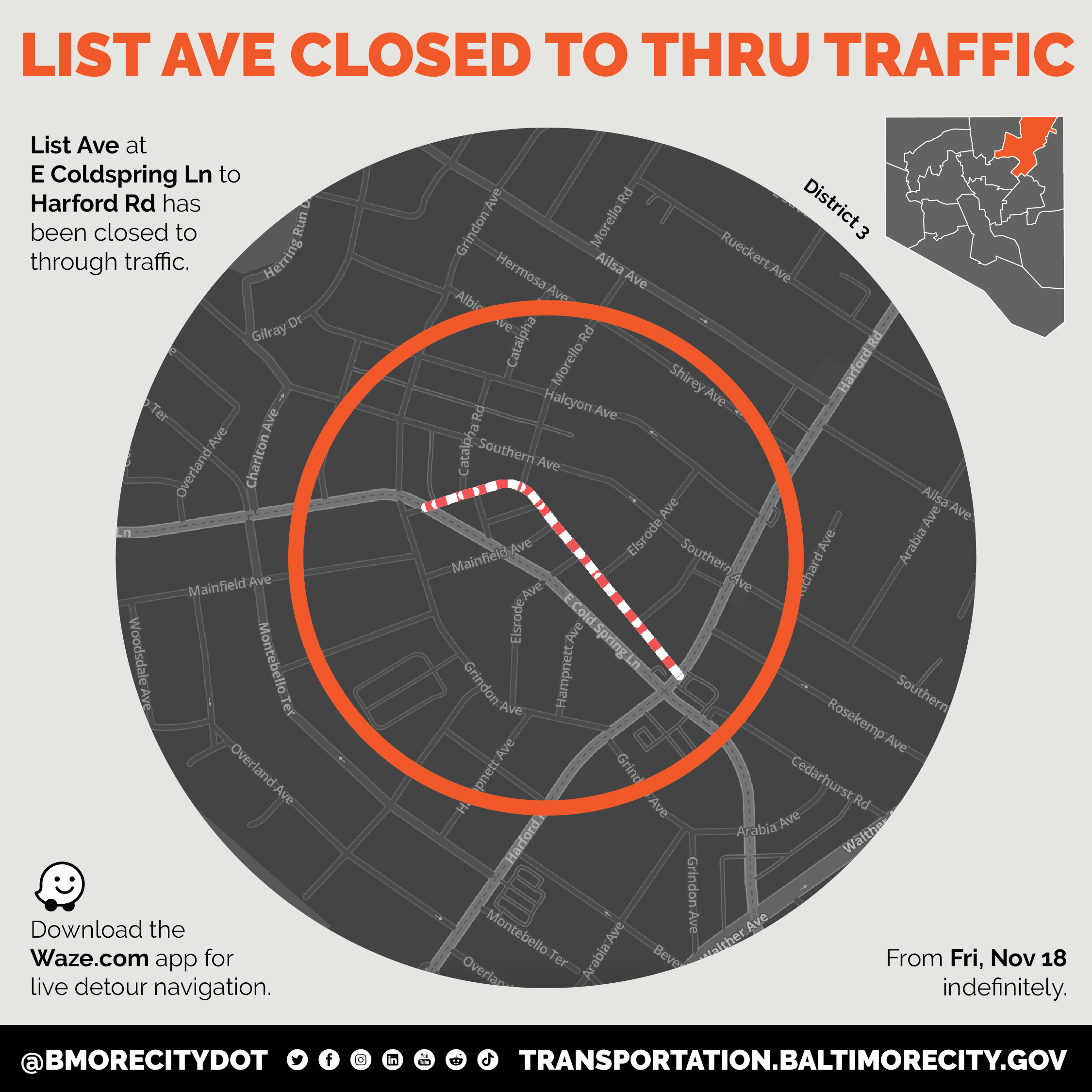
 List Ave at E Coldspring Ln to Harford Rd has been closed to through traffic. There have been numerous auto crashes due to motorists using it as a shortcut, and so we are closing the road to through traffic indefinitely beginning Fri, Nov 18.
AwkwardMachine t1_iwj96c9 wrote
Waze likes to take you through there and after I did it once and sat there for like 15 minutes in rush hour I never did again.
BmoreCityDOT OP t1_iwjc5mf wrote
It won’t anymore!
theghostofm t1_iwl26o7 wrote
Oh, oh! I have a question for you regarding Waze specifically: Do you guys communicate with Waze or any of the local volunteer editors? Aggressive routing like this can sometimes be mitigated by updating metadata of intersections on the map. Obviously it often makes sense to close through traffic like in this case, but perhaps sometimes there are map tweaks that can be made to help alleviate smaller routing problems.
BmoreCityDOT OP t1_iwl8mwj wrote
Well, this isn’t just a Waze update. Concrete barriers are being placed.
But yes; we work very closely with Waze reps and traffic professionals. We have a partnership with them, and any and all closures (temporary and permanent) you see us announcing are getting uploaded to Waze so you can use it to navigate around them.
theghostofm t1_iwl90se wrote
> Well, this isn’t just a Waze update. Concrete barriers are being placed.
Yep, I totally got that (The "try not to drive through the concrete barrier" comment is the best thing to come out of official City communication channels in the history of forever). But more clarification never hurt anyone, so thanks for communicating that!
> But yes; we work very closely with Waze reps and traffic professionals. We have a partnership with them, and any and all closures (temporary and permanent) you see us announcing are getting uploaded to Waze so you can use it to navigate around them.
That's cool to hear. One note: Your answer specifically mentions road closures, but my question was more about mitigation of aggressive routing in cases where road closures are not done. Is that something you also work on with Waze reps?
BmoreCityDOT OP t1_iwl9ezh wrote
Nope. We are only working with road closures at this time. Waze is constantly updating the map itself, so we’re providing them with the most up-to-date data of whatever we’re physically doing on the ground so they can do what they’re best at.
theghostofm t1_iwla9zz wrote
Interesting!
> Waze is constantly updating the map itself
I'm a part of that. For the past few years, I've been pretty active as a volunteer map editor for the city. I've added thousands of updates and additions, especially in East Bmore. One challenge is the fact that unfortunate routing problems are somewhat obfuscated from us. But if we were able to have broader insight into where we should mitigate these kinds of issues, it'd be great for Waze users and hopefully for city traffic in general!!
Oversimplified explanation: we have several different metadata we can apply to intersections and road segments which can impact how aggressive the routing algorithm will be with them. If we know about where there are likely problems with routing, we can work to improve them!
I don't necessarily want to add to your (likely considerable) burden, but I wonder if it'd be okay to suggest something like this: Would you guys consider sharing information regarding traffic patterns with the volunteers or reps?
BmoreCityDOT OP t1_iwlb9d5 wrote
We are so grateful for your work!
What we’d like to be able to do is share that data directly with Waze themselves so that they can make appropriate changes. The progressional relationship is rather new, but we’re planning on doing even more with them.
theghostofm t1_iwlbfye wrote
That's great! I'll stop bugging you after this, I promise, but I had one more thought.
What about publishing on https://data.baltimorecity.gov/? That would be amazing.
PM_ME_UR_CC_INFO t1_iwldm54 wrote
This is interesting! I have heard folks in my neighborhood say that Google and Waze route people through Medfield via Grandview Ave when 83 is slow. Is that the sort of thing you’re looking for?
If that’s what you’re looking for, and you haven’t already, perhaps reach out to community associations. Those groups will likely know if GPS routing is an ongoing issue in their area.
theghostofm t1_iwliw4x wrote
Oh yeah, that's a great example!
For reaching out to community associations, that's definitely something we do to some degree. Neighborhood facebook groups are another good resource.
Unfortunately, adding different individuals and groups makes a complex web of communication. The idea of getting some level of communication or data directly from the city DOT, which can quantify, collate, and highlight trends is so exciting because it lets us get more meaningful data, that's higher quality, with some expectation of consistency, without needing to navigate a network of complaints and hearsay gathered from a network of different sources.
The_Waxies_Dargle t1_iwjmul1 wrote
Are you the same team that ran the health department reddit?
BmoreCityDOT OP t1_iwjmy1p wrote
Sir, this is the Department of Transportation.
Koalasarebadforyou t1_iwl4jqb wrote
I wanna frostie
BmoreCityDOT OP t1_iwl8o5v wrote
We’re out of McNuggets.
Koalasarebadforyou t1_iwm5gh4 wrote
Can I get a uuuhhhhhhh gordita crunch
[deleted] t1_iwl7z33 wrote
I love that now that now that millenials and zoomers run the world, everything is responded to with jokes/memes. Like, if we're all going to be destitute, underpaid and overcharged for everything in life, with the world on the brink of total collapse, we might as well make dumb jokes from official accounts cause fuck it.
BmoreCityDOT OP t1_iwl8wzn wrote
At least we’ll have quiet, pedestrian-friendly roads. Net gain?
[deleted] t1_iwl9ppm wrote
You mean when we're all dead? Sure.
But we both know the better gain would be more/better public transit so that the roads were quiet because people weren't on them but still alive.
Any word on the red line coming back with Wes Moore?
[deleted] t1_iwlhh27 wrote
Btw, do orange stickers means something is getting towed? There’s been a heroin brothel trailer in a no stopping zone on Buena Vista Ave in Hampden for two weeks that I noticed finally has an orange sticker.
[deleted] t1_iwjohgs wrote
You’re running a social media account, I don’t think it’s a dumbass question. Irrelevant and not important, sure, but you didn’t need to meme him for it.
CallMeHelicase t1_iwjvaps wrote
Ok Karen
[deleted] t1_iwjz30l wrote
oh no my internet clout how will i recover.
Rhododendran t1_iwksice wrote
Small minds can only think of small worlds.
Viewing a single comment thread. View all comments