Comments
octopodes1 t1_j6nix60 wrote
I will say that rhe GLX has made me realize how fast it can actually go when there aren't tight turns and it doesn't have to wait at lights.
Master_Dogs t1_j6o25i9 wrote
GLX has some disappointing slow zones though at times. It seems like it bottle necks around Lechmere with the Union Sq Branch. And the end of the Line at Tuffs was slow asf the first time I went; hopefully they've figured out how to get trains in and out quicker.
It's lovely overall though and I wish we had extensions like it planned every 5 years to actually get some good transit going. And a big investment in ongoing maintenance to ensure we don't end up shutting down lines for a month like we did last year.
Sayoria t1_j6ngaif wrote
It already takes one and a half on the red from Braintree. So fair point.
capta2k t1_j6n6qli wrote
Obviously you would transfer at blue hill Ave! 😉
dahc573 t1_j6mtfej wrote
Realistically the green line should go to at least Indiana
hannahbay t1_j6on9gp wrote
As someone with family in Indiana who goes back multiple times a year.... I'd rather fly
IDCFFSGTFO t1_j6mnfz9 wrote
I really expected yet another "fuck the south shore" MBTA fantasy map. Pleasantly surprised.
hero_ad_interim t1_j6nlrez wrote
Yea this is good but I think it kinda screws Holbrook proper and makes a literal outline around it. I think maybe an Abington line would be good but that might be a lot of extra
General_Liu1937 t1_j6pe3f5 wrote
It doesn't properly service Randolph nor Holbrook, so it really is fucking service at the station over as a whole. Neither town is benefitting all that well from it.
karter0 t1_j6mj6mu wrote
Still no train to Southie lol
northeast0 t1_j6mo8mr wrote
Also the silver line does a little loopty loop around the airport terminals before stopping a mile away
Good luck visitors!
QueenOfBrews t1_j6nu2o5 wrote
You do realize Southie has two red line stops as it is, right? Admittedly, they aren’t conveniently placed depending on where in Southie you are going, but saying “still no train to Southie” is a bit much.
northeast0 t1_j6mnnbd wrote
How long would the Salem -> Quincy Adams ride take? 4 hours?
Train access to Blue Hills would be lovely though
[deleted] t1_j6mtwc0 wrote
[deleted]
northeast0 t1_j6mwjbs wrote
Thank god it’s not the D line
-- signed, Newton
Large_Inspection_73 t1_j6pgf40 wrote
Faster to walk
kmoonz88 t1_j6p1v2s wrote
how long does it take now tho
PLS-Surveyor-US t1_j6mtnl9 wrote
Monthly Pass .... $4000
Taft_2016 t1_j6onl6y wrote
Or maybe the people who benefit from the interconnectedness of a mobile population (everyone) should pay for the services required to support it (transit) through a small stipend (taxes)
PLS-Surveyor-US t1_j6paq1s wrote
Taxes ..... 99.2%
IDCFFSGTFO t1_j6pbnxi wrote
Just hold down the L button, set tax rates to negative value, go with the figures, release L button. $9999999
Slapshot5251 t1_j6m7gvt wrote
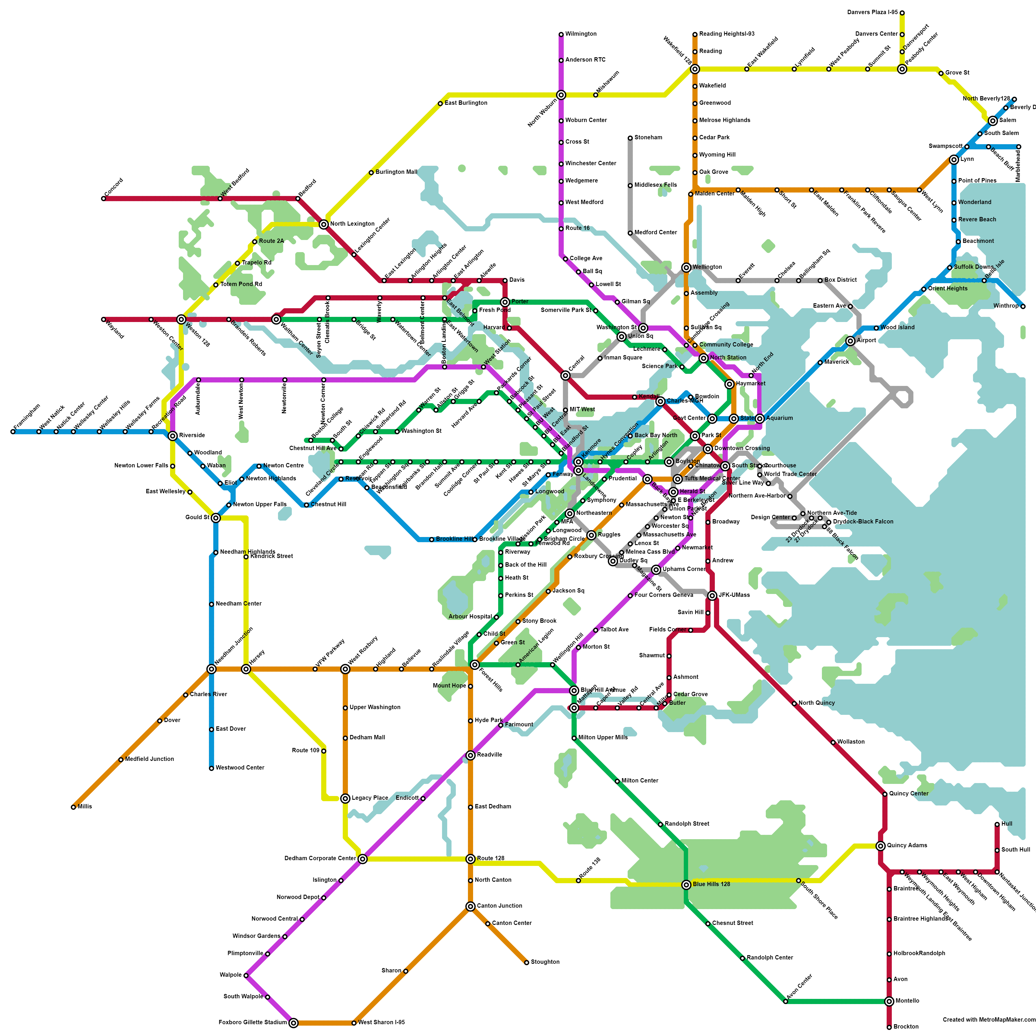
Interesting map. Orange line to Gillette stadium is wild lol. I would move Cambridge Crossing on the purple line east as Lechmere and Comm. College are already pretty close together and the part of Charlestown near the Mystic and Boston harbor is kind of a transit desert
psychicsword t1_j6mqrdr wrote
So we are just undoing the Medford section of the GLX and reworking it to be an entirely new line that somehow cuts through the north end?
Ok-Pin-4379 t1_j6n4fv0 wrote
No GLX is the first thing I noticed too
Master_Dogs t1_j6o2jft wrote
I think GLX is still there - at least North of Lechmere. It does a weird turn towards Cambridge Crossing, which I think is useless since Lechmere is already basically serving that area well enough. I believe they took over the Lowell Line ROW for that, totally unnecessarily because you'd probably still want at least a single track Lowell Line to serve points north of Woburn on this map.
It does an interesting branch at North Station too, which there's some historic precedence for - the Orange Line used to do that same thing back in the early 1900s. I believe it was elevated though; not sure if this map assumes that or tunnels.
psychicsword t1_j6ohatk wrote
The GLX stations are there but most are no longer connected to the green line at all.
It is impossible to get from Ball SQ to Lechmere without connecting between the Magenta line and the Silver Line to get to Union and then taking that 1 stop to Lechmere. That is an extremely bizarre decision especially because it doesn't factor in the fact that there is already a ton of infrastructure to connect those together directly.
What would have made a ton more sense would be to have the Washington Street Magenta station continue to Somerville Park St and then Porter Street and the whole new branch to Waltham Center would be the Magenta line rather than a Green Line.
Wide_right_yes OP t1_j6p5eof wrote
Yeah I can clean that up
_peteyfourfingers_ t1_j6mcjxf wrote
I love the red line extension out to Concord. Make it happen, dude.
DeBurgo t1_j6mw57i wrote
>Extremly Unrealistic Fantasy MBTA Subway map
I remember when people on this subreddit used to post these kinds of maps saying they were the "future mbta" maps like it was an inevitability or even something that was planned by anybody. At least now people are realistic about how unlikely this is at this point.
WinsingtonIII t1_j6mzisy wrote
Eh, this one goes way beyond many of those maps. Something like Blue Line to Lynn realistically won't happen but it's arguably possible.
Green Line to Brockton would never happen, the distance is incredibly long for a light rail line (17 miles from the city center). But OP is fully admitting that it's extremely unrealistic.
Ruleseventysix t1_j6nrn2r wrote
Now now, we can build the tracks, stations, or trains. You can only pick one. Trains have a delivery date of 2060 at the earliest, stations are a no go, and the tracks are easy we just have no place to put them..
SkiingAway t1_j6n3fq2 wrote
Branches are bad, long branches of varying lengths are worse.
As reminder, every time you branch, you split the mainline frequency. Every 3 minutes on the main line turns into every 12 if you've got 4 branches and you're feeding them equally. If they get high ridership, you can further than run into the Green Line situation where it is physically impossible to stuff more trains into your mainline and so you can't raise branch frequencies further.
Beyond that, the longer the branch the harder it is to feed the trains into the mainline in their intended scheduling/order - there's more that can "go wrong"/vary.
RedditUser934 t1_j6o59gt wrote
Sounds like this can be solved by replacing a branch with a separate line. The downside is that you need to change trains to get downtown.
TheManFromFairwinds t1_j6nc625 wrote
That urban ring is too far out. If you do this you need something closer, otherwise you're still going downtown to do any transfers.
hero_ad_interim t1_j6nea4c wrote
It's like a suburban ring. Honestly, I don't think it's that bad to have if there was an inner ring too. What would the inner one look like? Roxbury/Dorchester > East Newton > Medford type of thing?
TheManFromFairwinds t1_j6nhsth wrote
I'd still say that's too far out, if you're in somerville and want to go to allston you'd still be stuck going downtown first. Something like this sounds good to me.
https://www.reddit.com/r/boston/comments/5wm9z7/three_years_ago_i_created_a_hypothetical_future_t/
Master_Dogs t1_j6njlvj wrote
They did an inner ring - it's based on the classic MBTA Urban Ring proposal from the looks of it. It's the Silver Line basically that runs from the Airport to Wellington to Union to Central then to BU / Longwood / Ruggles / etc.
You can see the similarities in the MBTA's proposal here: https://en.wikipedia.org/wiki/File:MBTA_Urban_Ring_map.svg
I want to say they basically copied it. Maybe there's some slight differences I'm not noticing - like the lack of a proper Airport station on their map, vs the T's proposal would actually have one in that little loop de loop.
TheManFromFairwinds t1_j6nr47s wrote
Turns out I'm fucking blind. Thanks
Master_Dogs t1_j6njr5h wrote
They have that included as the inner Silver Line, which appears to be based on the T's own Urban Ring proposal from the mid 2000's. You can spot the similarities with the T's proposal: https://en.wikipedia.org/wiki/File:MBTA_Urban_Ring_map.svg
Master_Dogs t1_j6nf0ea wrote
I think they used 128 for one of the rings, and then they sorta did the T's original Urban Ring closer to the center. It's a cool idea to use the highway as another ring, but ultimately not super useful I think since that makes it really tricky to do transit oriented development (people don't want to live next to a highway and the highway adds distance for walking, biking and bus connections).
Large_Inspection_73 t1_j6pgoqs wrote
We need two or three concentric rings
StovetopGiraffe t1_j6mvlsa wrote
Everett and Chelsea still getting the shaft I see
Stronkowski t1_j6ncdqs wrote
Hey, they get 5 new stops!
..out of about 7000...
and they don't even go downtown.
2wo2imer t1_j6m7uys wrote
Do you think Avon would even be able to fit two stations? Ain’t nothing there
Wide_right_yes OP t1_j6m87ch wrote
One is on the border with Holbrook on the commuter rail line and the other is in downtown on Route 28 on the Green Line running down it.
hero_ad_interim t1_j6ndbc2 wrote
This is good because you get the High-school plus the corporate stuff and then also where alot of people live
johnmcboston t1_j6mydzy wrote
Almost looks like a real city
Stronkowski t1_j6ncle0 wrote
You added like a million T stops, but still didn't put one between Wellington and Malden Center.
Master_Dogs t1_j6nf761 wrote
Yeah that's a pretty key infill station. Lots of potential for transit oriented development around that area with lots of under utilized land.
Stronkowski t1_j6oud1j wrote
Could be some serious new housing there, not to mention all the existing people in Malden/Medford/Everett who could suddenly be in reasonable walk of the stop.
Wide_right_yes OP t1_j6o8419 wrote
Will include that in my updated map.
puglord t1_j6n21fw wrote
Missing central Brighton. My wife works at a medical office across the street from St E’s which is basically the reason we still have a car. A line running down down Cambridge St would be beautiful, that area is car hell.
Add a Castle Island extension from Broadway for the hell of it too!
JumboChimp t1_j6n7t4o wrote
Once upon a time that was the Green Line A branch, which ran to the intersection of Galen St and Nonantum in Watertown. The 57 bus more or less follows the same route.
puglord t1_j6nbcmw wrote
It should really be considered again with that new West Station development planned nearby!
JumboChimp t1_j6ncwt0 wrote
One problem would be that it ran in the street, not in its own right-of-way, and I don't think that would fly today, but the bigger one, the thing that killed it, is the Newton I-90 interchange. Before the Pike the A branch crossed the railroad tracks on the Washington Street bridge, which carried traffic in both directions. After the Pike, that bridge was one way northbound for cars, but two way for the trolleys. In theory, so long as traffic followed the lights vehicles wouldn't get stuck on the bridge blocking the trains when the southbound trains had the green. In theory.
I have concerns about West Station too, because it's very close to Boston Landing, and having stops super close together slows things down.
DunkinRadio t1_j6mvesg wrote
How about a Silver Line equivalent for North Station?
Us north of Boston air travelers deserve some love too.
3720-To-One t1_j6mx51o wrote
It needs another inner loop approximately with the 86 or 66 bus goes.
Love that the Millis line is reborn.
Current-Weather-9561 t1_j6mx558 wrote
Big Auto would never allow this lol. I like the silver line light rail idea, but I don’t see how it happens above ground.
Maxpowr9 t1_j6n1hme wrote
In so many iterations, why don't they ever join up Cleveland Circle and Reservoir?
Master_Dogs t1_j6nk7t4 wrote
Separate terminals, separate lines -> not much point to joining them. They're walking distance anyway, and if we improved bus/bike connections plus gave both the B and C lines dedicated ROWs you wouldn't really care which one you got on.
hero_ad_interim t1_j6ndrhx wrote
The actual stops available seem great to me. You hit a lot of the good areas on the south shore but I think the layout of it overall is a bit messy with some lines being ridiculously long or winding.
Mistes t1_j6nq7zu wrote
I still can't get from Allston to Cambridge/Harvard in less than a 30 minute walk - would like a line to connect the two in an ideal situation
Lordgeorge16 t1_j6n1ntl wrote
How come you replaced the Franklin/Forge Park CR line with a heavy rail purple line, then cut it off just a few stops before the terminus so it could go to Gillette? Seems like a strange design choice. Everything else looks pretty neat.
Also "Hingham" was spelled incorrectly twice.
taxwithoutrep t1_j6n48ny wrote
The people of Dover would have a collective aneurism if any rail came through. Let alone the orange line.
fins4ever t1_j6n5jsn wrote
Ahh the Danvers t station makes me smile
Vdawgp t1_j6n6cz8 wrote
If we’re really swinging for the fences, then I would include some bored commuter rail tunnels out to Logan so that the Newbury/Rockport line can have an Airport stop. And while we’re at it, may as well add each terminal onto the Blue Line.
benck202 t1_j6n79kf wrote
Drool
Tiny_Ad5242 t1_j6na35c wrote
The green/red intersection at Porter
Fortheloveofgawdhelp t1_j6niejh wrote
I would trade all of it for the Milton center green line and VFW parkway in chestnut hill on the orange line; I’ve wanted those two connected to the t since I moved here
DrToadley t1_j6njztl wrote
Hey, if we're being extremely unrealistic, expand commuter rail to Burlington VT via Concord NH
albertogonzalex t1_j6mlksr wrote
Love the yellow line but feels like it should go through Forrest Hills.
SynbiosVyse t1_j6mndes wrote
> Forrest Hills.
Run Forrest, run!
Sheol t1_j6o1xhm wrote
Only a five and a half mile detour one way!
The Yellow follows RT-128 which would make detouring to Forest Hills pretty absurd. This map decided to put the inner ring along the 47 Bus instead of the 66, so there's a pretty big gap between the Silver and the Yellow.
albertogonzalex t1_j6o49py wrote
I was just trying to make a direct connection between alewife and Forest Hills.
Wilforks t1_j6n2gq1 wrote
The yellow line seems a bit much, with that much line extension and intersection already, it’s probably better as a few local buses.
If they just extended the mattapan line and E line to Forest Hills, the city would be much better connected. Orange line out to Readville/West Roxbury would make sense and would be at least a little bit realistic, since there’s already right of way and track down those routes.
Master_Dogs t1_j6nlh57 wrote
> The yellow line seems a bit much, with that much line extension and intersection already, it’s probably better as a few local buses. > >
I think in a world where we actually do all the inner transit projects they've listed (Red, Orange, Green and Blue Line extensions outward via rail / trail ROWs, light rail conversion of the Silver Line, Commuter Rail turned into a proper Purple Line via Electrification and Signal modernization, etc) the yellow line becomes extremely valuable. Someone who lives in Waltham but works in Burlington no longer needs a car at all. They've got access to downtown PLUS the suburbs. And someone in Salem could get to Burlington without a car too. While still having access to downtown, and potentially cutting through via a Blue/Red transfer if they wanted to go to the South Shore.
128 appears to be the routing of the Yellow Line, and it's constantly congested. Being able to take, idk, 20k cars minimum off that roadway and put them onto heavy rail of sorts would be killer. The lost of 2 lanes of motor vehicle traffic would be more than made up for by the reduction in traffic.
> If they just extended the mattapan line and E line to Forest Hills, the city would be much better connected. Orange line out to Readville/West Roxbury would make sense and would be at least a little bit realistic, since there’s already right of way and track down those routes.
A lot of rail ROWs exist for these proposed extensions, so really this isn't too unrealistic. The unrealistic part is funding it all and convincing millions of car owners that transit is actually a good thing for traffic and providing alternatives to driving. It's slowly catching on, but there's enough resistance to make this an uphill battle and not many Governors/State officials will bother with that.
Wilforks t1_j6nnfvk wrote
I think the length of the line is a part of the problem though, the number of trains needed to keep the line running frequently enough to make it convenient would be so high compared to ridership that it wouldn’t make sense as an investment in space and resources.
Master_Dogs t1_j6o1t2e wrote
Hmm, possibly. MA 128 is 57 miles long according to Wikipedia. The longest subway route in NYC is 32 miles long according to Google. I don't think the OP did the entire length of 128, since it cuts over to Salem instead of going to Rockport. So it might be a stretch to make the Yellow Line truly subway like (5-10 minute headways) but there's a number of Commuter Rail Lines that are that long (Fitchburg Line is 54 miles long apparently) that have hour or so headways. I imagine you could get 20 minute headways without totally breaking the bank, which might be useful enough for some folks.
I agree it's not a great investment, but in the Grand scheme of things we spend billions on highway maintenance each year (last I saw, something like $1.5B through MassDOT) so if we wanted to divert some of those resources, or increase taxes to fund more transit, at some point a Yellow Line would make some sense. But not until we've gotten the inner line running, and all the various extensions to 128 in the first place. Even then I don't know if running rails would make a ton of sense. Rapid Bus service might make more sense and be a lot cheaper. Just take 1 lane on 128, make it a bus lane, add some cameras/cops for enforcement, and run buses every 15 minutes. That would probably be totally affordable, especially since bus stations are dirt cheap and buses aren't terribly expensive.
METAclaw52 t1_j6nidjt wrote
I love this, great work
meow_haus t1_j6nkoaj wrote
Forest hill to Watertown
Prestigious_Bobcat29 t1_j6not21 wrote
Absolute fantastical wet dream transit map and we still can’t get a god damn line to southie
BigHmmEnergy t1_j6oqxyb wrote
Pretty good. Although I think your subway lines go too far away from the city. Foxboro, Brockton, Framingham, basically anything outside 128/95 would be better served by high frequency commuter rail with local/express service. I agree with converting the Green Line D branch to an extension of the blue line via a new tunnel past Charles/MGH through the back bay, although I wouldn’t extend it past riverside. I’m also surprised you didn’t restore the A branch to Watertown.
Wide_right_yes OP t1_j6oupr7 wrote
I did green line to Watertown on a different route.
SynbiosVyse t1_j6mge3w wrote
That's not North Canton. It is North of 128 like where the Dunkin HQ used to be. The stop called 138 you have would be more like North Canton.
I understand why you put the stop there, but just needs a different name.
notorious_zero t1_j6mky4w wrote
I currently live in canton, and if he’s following the commuter rail alignment for the orange line out of forest hills, then north canton doesn’t need to exist. I take the train every day, and will in about an hour. There is nothing of value between RTE 128 and Canton Junction. It’s houses for less than a mile and then a series of separate industrial parks interspaced by small plots of woods.
SynbiosVyse t1_j6mnglu wrote
That's true, the stop would not be widely used. But just reduce the 2 guys who ride on scooters everyday over the Dedham st bridges from Rte 128 station to the Shawmut industrial park.
winter_bluebird t1_j6mm8yd wrote
That Concord stop would change my life.
pikalaxalt t1_j6moi5c wrote
Close Bowdoin, then we'll talk.
CoffeeWarlock t1_j6mzh0b wrote
I think the red line should branch at North Quincy to add a Long Island stop.
No-Ratio-4082 t1_j6nhqhs wrote
Please lord Danvers and west Peabody 🙏🏼🙏🏼
Minimum_Ad5752 t1_j6nkhc2 wrote
This would be amazing !!!!
Minimum_Ad5752 t1_j6nkozf wrote
I want Orange line to west Roxbury and roslindale village 💯
therealcmj t1_j6ntaao wrote
Take the silver line and continue past JFK UMass to actually go to UMass. Then turn left and connect it to Drydock through Southie
Jmat417 t1_j6nvxsq wrote
The map scale to size is just so bad. This makes Brockton look likes it’s a coastal city
Wide_right_yes OP t1_j6o8do1 wrote
The scaling isn't great on this map
MrFusionHER t1_j6o0s58 wrote
Well the GLX already exists so... ???
likezoinksscooby t1_j6o4niw wrote
I think it makes more sense to have the urban ring go through longwood than Kenmore. Maybe have it cut through Coolidge Corner and down to Harvard St on the B branch. Most people are going to Longwood anyways so it’d save them the transfer + people on the outer parts of the Greenline wouldn’t have to go as far to transfer
GatorladyinTigerland t1_j6o9nyr wrote
This is beautiful and needed
purplepenny23 t1_j6oac9p wrote
I’m laughing at the thought of a train station in Wayland Center… I mean I know there WAS one there… but those N. Wayland people are known for their NIMBY attitude
Source: I grew up there
tool22482 t1_j6oh6w8 wrote
As a resident of Reading I must ask, what the hell is Reading Heights, lol
Wide_right_yes OP t1_j6ohg3v wrote
I saw Reading Heights on an old map someone else made, I don't know anything about Reading. The station is on route 129 near I-93.
Hypothian t1_j6omfge wrote
id like a red line green line connection that goes to brighton, instead of taking the hour long loop
cannonballdone t1_j6oneiw wrote
Gamechanger
Taft_2016 t1_j6oo0u8 wrote
Honestly love this. I'd bring the yellow line in a bit to service heavier populations, but I'm always amazed that the only way to get anywhere in greater Boston is to go downtown
[deleted] t1_j6ooki7 wrote
[removed]
whalelabos t1_j6ore13 wrote
Loveee these kind of maps. Blue line to Marblehead made me LOL, I’d love to see it but know that would never happen. Thanks for sharing and so fun!!
Lance_Halberd t1_j6ork22 wrote
Zooming a little further out, one could theoretically connect Lawrence to Newburyport along the abandoned rail bed that heads east from Bradford Station, with only a minor amount of eminent domain in a couple of spots.
You-Only-YOLO_Once t1_j6otnid wrote
Mmmm! Love that blue line from Brookline Village to the airport!
patwm11 t1_j6owjv7 wrote
I like how the current red line stops at Ashmont then you have to transfer for the mattapan line if you choose to, otherwise if they were connected it would be a whole lot more sketchy
TheRainbowConnection t1_j6p31rb wrote
Just needs a direct North Station/ Airport connection!
staffnasty25 t1_j6p3l8v wrote
Oh look. It’s still a pain in the ass to use public transportation to go from Cleveland circle to alewife despite them being 3 miles apart.
kobuta99 t1_j6p7enk wrote
One of the biggest weaknesses in our current subway is that to if you don't live centrally in downtown Boston, you have to go into downtown to take a line that then goes west/north/south. Our lines need more connections at the outer points of the map. If you go to Tokyo,JP, one of the great things about their subways is that the map is more like a spider web. Rather than just spokes that all lead into Tokyo, they have ways to connect so you can avoid going to the central hub just to go back out.
lilbitspecial t1_j6pb0ux wrote
*Totten Pond Road. Not Totem Pond.
Ready-Divide-9703 t1_j6pb6vt wrote
MIT West sends blessings
[deleted] t1_j6pb7s7 wrote
[deleted]
General_Liu1937 t1_j6pe9z6 wrote
I think it's okay, but converting perhaps commuter rail to just high frequency lines and making direct North-South station access would give generally positive benefits as is.
Itchy_Honeydew8219 t1_j6piunb wrote
Reading Heights is making me laugh! 😂 I grew up in Wilmington, so that’s funny!
Wide_right_yes OP t1_j6pj5uw wrote
I made a mistake its actually Reading Highlands I believe.
SuckMyAssmar t1_j6n3mxh wrote
The silver line is NOT a bus line.
Lord_Ewok t1_j6pa1kv wrote
/r/fuckcars wet dream
Pretty much nailed every NS spot
Large_Inspection_73 t1_j6pgdye wrote
How come none of you fantasy train weirdos ever consider where existing and former railroad tracks run for your proposals? Obviously any new subway or commuter rail lines would utilize those ROW before bulldozing existing communities or building tunnel at a cost of $3 billion per mile.
Wide_right_yes OP t1_j6ph6yg wrote
Most of these extensions use existing or abandoned row if possible.
Neuroticperiscope t1_j6mah26 wrote
The repeated DIY subway alternatives on this sub are one of the it’s singular idiosyncrasies
doctor-rumack t1_j6mopv9 wrote
Could you imagine taking the green line in from Brockton? That would take 3 days.