Submitted by Eyusd t3_118832k in dataisbeautiful
Comments
smauryholmes t1_j9fy8sc wrote
Mind sharing your code? I’ve been using a paid service to do this at my job and would rather do it for free haha.
I assume you need Maps API access?
Eyusd OP t1_j9g3sus wrote
I didn't want to spend money on that, so I just used Selenium to simulate what a real user may do.
This whole code is just a big bodge. I just control the web browser with the script, and instruct it to type into the search input coordinates, and scrap the page to retrieve the times.
If you'd like a better way to do this with an API, reach to me in DMs, I'd be happy to help
liotier t1_j9gy1q6 wrote
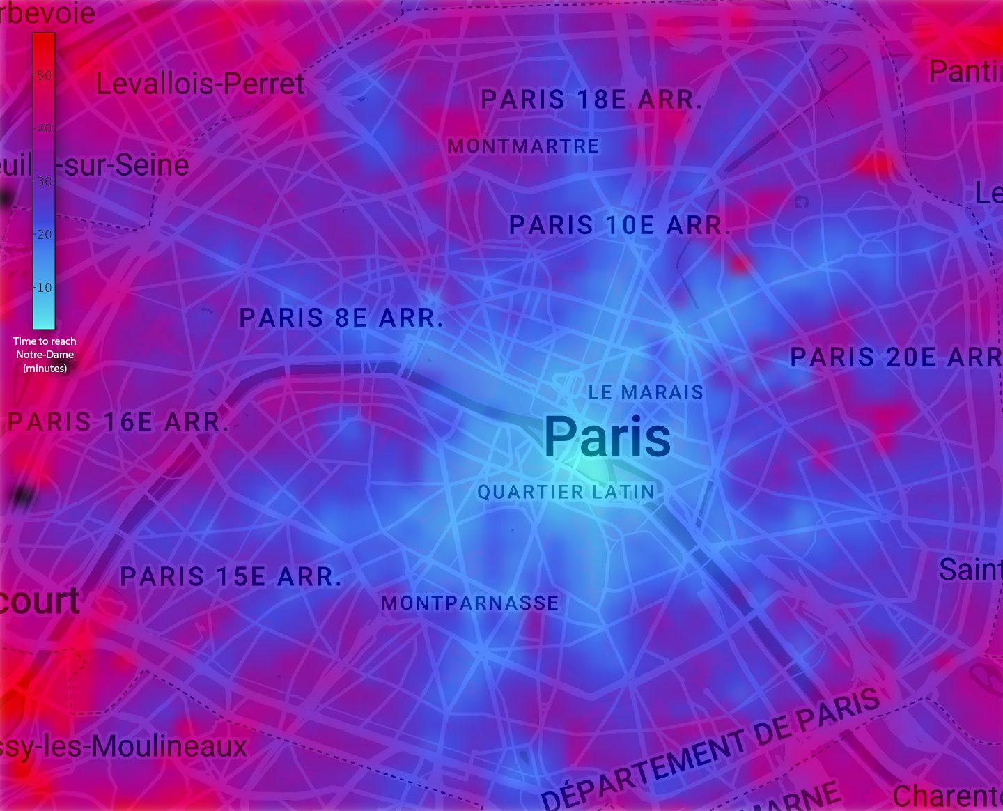
Choosing Notre-Dame as center is strange, as the nexus of the Paris transportation network is Les Halles, just a neighborhood away.
Notre-Dame is point zero of the French geodetic network and of the French road network - but that is not relevant to a mass transportation isochrone.
B33Man88 t1_j9fopu3 wrote
Now do the map if you’re a fire
chew_stale_gum t1_j9ftca4 wrote
This is cool. Would you open source the code to do this?
I hope to do something similar and look at changes during rush hours and arbitrary destinations. To better understand the variance in commute time throughout the day.
Eyusd OP t1_j9g399t wrote
Unfortunately, I think my code won't help you that much. As I dont have access to any maps API, I basically just used Selenium to simulate inputs as a real user would do. This is time consuming because the whole page has to render, for nothing.
If you don't mind spending a few bucks on a Google Developer account, you may have an easier time achieving your goal using their API.
I'd be happy to help if you need.
bunnnythor t1_j9gs96p wrote
So some places are so close they are blue-shifted and some are so distant they are red-shifted? Just how big is Paris anyway?
PmMeYourBestComment t1_j9fsty7 wrote
Paris is a whole lot bigger than this.
joaomsneto t1_j9g028g wrote
If you count Metro area of Paris, right? The administrative region of Paris is exactly this size.
tommytornado t1_j9gy4v5 wrote
The dotted line in the diagram marks the boundary of Paris.

Eyusd OP t1_j9fpcv5 wrote
A bit of context :
This was done using Python. The algorithm works by asking Google Maps what is the fastest route using public transports from any point to Notre-Dame, on 02/20/2023 at 4PM.
Changes from a subway line to another are allowed, as well as walking or taking the bus.
EDIT : Also, Notre-Dame as been chosen because it is roughtly at the center of Paris, and the starting point of all distance measurements in France