Submitted by TravelTime_LKB t3_123rl5v in dataisbeautiful
Submitted by TravelTime_LKB t3_123rl5v in dataisbeautiful
And orography. Spain is hilly af. It affects the cost of railroads.
True, but then Switzerland would look very different. It’s less about cost and more about need.
Well in Switzerland you can clearly see the mountains. The North has mostly only small hills while the high mountains are in the south where there is significantly less public transport (and a much power population density)
*lower. FTFY.
Considering most people in the mountainous regions live in the valleys, they usually are not much worse connected to PT than the rest (compared to population), but yes in total numbers there is significantly less PT.
Because Switzerland had no other option, Spain has longer routes through plains.
Switzerland
Canton with less meters above sea have its capital have an elevation of 373m
Canton with more meters above sea have its capital have an elevation of 512m
Spain:
City with higher elevation in the peninsula: Avila with 1131m
And a lot of cities in the coast.
The diference in elevation is higher in Spain. The same train can (theorically) travel from Avila to the north coast.
In switzerland the trains not only connect the capitals.You can drive with the train to jungfraujoch 3454m.If you drive from Chur 515 to Brig 491 (both capitals) you can drive up to the Oberalppass 2042m down to andermatt 1400m and up again to furka 2100m.
Allthough its faster to drive the long way around with the tunnels.The huge benefit is that switzerland is so small, way easier to build lasting infrastructure.
i just checked for lulz.
Avila-valladoid-gijon with train only is 2400m up and 3500m down with 393km.
Brig-andermatt-chur with train only is 4100 up and 4100 down with 280km.
There are no mountains at all until 110kms before Gijón, then it gets mountainous af for a while but there are tunnels. The centre of Spain is elevated, but plain. The reason there aren't more railways there is because it's basically empty.
Source: I'm literally on the Madrid-Valladolid-Gijon route right now.
Bound to Madrid or Gijón? If it's the latter, please drink a Sidra on our behalf. :-D
Already did, but will do again tomorrow for you!
Switzerland is comparably rich though
But most railway lines were built when Switzerland wasn't rich yet. I think it is rather that a lot of railways, especially the ones in the mountains weren't dismantled because they were still usefull and powerfull in comparison to early cars
When Credit Suisse (RIP) was founded in order to build the trains and tunnels, Switzerland was already becoming established. And in Swiss fashion, they built a network that’s worth paying for. (It helped that the neighbors also appreciated being able to transit goods through Switzerland, of course.) Today, I spend more on my rail pass than I ever would when I lived in the US, because the utility is so much higher. I can go everywhere, and do it quickly, quietly, and efficiently. Every regular train leaves at the same time past the hour on the same track every time. I can plan a route including which track I’ll arrive and depart from months in advance, or just look at the clock and know how many minutes to my next local train right now. (And all the trains here are hydroelectric powered so it’s guilt-free travel.)
The Swiss mentality is to think about perceived value and build around that, and the trains are no exception. They continue to be built out and upgraded, and I encourage most tourists to forego the car rental and just take the train.
That's fair! I mean upkeep still isn't cheap but that big initial cost of setting it up was already paid for. Projects like the Gotthard Tunnel are still nothing to be done by a poor country
Yeah, I agree. I think the quality (infrastructure, maintenance and rolling stock) and quantity of (unprofitable) transit services is a bigger sign of how rich a country is than the sheer amount of train tracks.
>bigger sign of how rich a country is than the sheer amount of train tracks.
While I mostly agree these two might still be correlated. You see this on the map of italy. Italy is divided in a rich(er) industrialised north and a comparably poor rural south. Having railroads doesn't make you rich or vice versa But I think there is still a connection to be observed when you specifically look at the history of a country and the developement of a railroadsystem, don't you think?
I think I get what you mean. When the railways were built Switzerland (like northern Italy) were still somewhat rich (and more inland, less boats) in regards to southern Italy, so they built more railways. This goes the other way around: Railways tend(ed) to attract people and industries. Many cities in Europe but especially in the US were built because of the railway. There is probably a correlation between how rich a country is, how much tracks it has, when they were built and how the service is today. I find it pretty hard to see a direct connection, but imo it should work as a rule of thumb.
But Switzerland is tiny.
This. Spain is much bigger, which pushes up cost of construction and more importantly, maintenance.
But Spain has more people to collect taxes from so it kinda balances out
It also has lower income per capita. Switzerland is very rich in comparison.
Agreed! Population would help us understand transport demand, whilst geography will impact where stations can be located.
This is not just trains. For my area of Germany this is way more than just the train lines and it is titles "public transport". So i guess that includes all regular bus lines as well.
In this case lower population density and hills shouldnt be that big of an issue.
Of course places with hardly any population at all like mountains dont need even buses but thats hardly the case in most of spain.
It isn't really cheap to build on swampy soil either. It requires months for soil/sand to set, digging requires constant pumping and anything build up requires piling to be stable. One tunnel in the Netherlands was postponed over 5 years because it kept filling with water, for example. The geography matters, but it is far more complex than orography alone.
Mmmhm. All that big empty part is flat, but then if you look at Asturias (hilly af) it's super full of train lines. I really think the lack of lines in the centre is because no one lives there.
Everything should be on the same scale too. Mountains, rivers but also sheer size tend to make a difference. The Netherlands are much smaller than France, so obviously building a rail network is going to be much different.
We have the biggest amount of high speed railroad in the world only China wins us and i mean total numbers not adjusted.
What you are seeing in the north west are mostly bus lines th.
Yeah, but Germany for example has not just railroads being shown
https://www.youtube.com/watch?v=pL8XPZp4-5c
TL;DW: its not just about geography, but also poor government policy, which exacerbates the "problem".
Yeah, topography plays a big part, though tbf part of that is also it tends to decrease population density. So chicken and egg in a way.
It would also be interesting to see a comparable scale. Belgium is randomly depicted as three times the size of the UK.
Yup. Right now Germany looks way denser than for example Belgium, but I bet that if you put them at similar scales it's more likely to be the other way around.
I am pretty sure that map is not accounting for a lot of train lines that I don't see represented. Also, there is a huge network of bus lanes for medium and long distances.
I don't know how they have done it but in other countries train lines are continous lines while in Spain are just dots.
I was thinking this and came here to see if anyone else noticed. Spain also has some of the best intercity rail lines in Europe.
exactly, in general public transport in spain is top notch speaking from a german perspective. Shit just arrives on time, good and fast intercity raillines, suburban trains work well, and so on. There’s a lot of pop in spain concentrated around the bigger cities - and the land is huge, no need for the same density than eg germany. Bcs it’s less dense and I think I read their trains with goods / wares use different rails than their intercity trains, shit works better than in germany where every rail is working at or over its limit and shit is constantly late / cancelled bcs one minor issue creates a big chain of other issues. The things I said about spanish public transport can be extended to french one as well.
Some of it is an illusion because the countries are all pictured the same size. The most densely populated part of Europe is northwest Germany and Holland. The area where the two countries abut have similarly dense railways, but it appears here as if the train lines thin out suddenly as soon as you cross into the Netherlands.
Also with level of industry / development. Southern Italy is a little less dense than the north but also way more agricultural & lower wages as people will be fine running their small olive or lemon farm by hand.
Thing is, these are explanations.
It’s just that I don’t think that two maps of train lines can be compared to each other without accounting for different distributions of population, that’s what my comment was about.
Pretty funny how Switzerland is bigger than Germany. Makes it look like Germany has a much higher density, which it probably doesn't.
That's my bad with the zoom levels, although I had a look using the same scale for each country and Germany 'appears' to have better coverage to Switzerland still - I use inverted commas as obviously Switzerland's geography obviously has a big part to play in this!
it probably looks like this because, in Switzerland, the density in the dense parts is "denser" than in Germany
Switzerland Germany
Population: 8,703,000 83,196,000
Inhabitants/km²: 210.8 232.7
They said dense parts, compare Berlin to zurich
Population density Source: Wikipedia, 2023.
3900 people/km² Berlin
4092 people/km² Zürich
Still not directly comparable, especially using arbitrary city boundaries
It would be hard to do but the most apt comparison is between all of the swiss lowlands in the north vs an equivalent size area of germany
swiss lowlands 10'062,05 km²
Inhabitants/km²: 380
Which region of Germany should I use so it can be comparable?
The Saarland has a population density of 382. However, regardless of the actual density, every dense region will look completely red. It's just that Germany has no large uninhabited areas whereas the Alps in Switzerland are almost uninhabitable.
TLDR: Switzerland's network is denser, it just has bigger holes
Swiss train service is a lot better though we can agree on that. Without looking down on the Deutsche Bahn.
That's arbitrary as well.
You cannot tell the efficiency of a countries public transport just by looking at the dots, maybe more busses/trains go through them and more people use it.
I think this has a lot to do with the Alps that cover more than half of Switzerland. Actually Mountains cover 69% of Switzerland.
I don't know if you looked at rail only or at all methods of public transport, but here's what I found about rail only.
Germany has 461 km of rail per one million inhabitants. Switzerland has 609 km of rail per one million inhabitants.
Germany has 109 meters of rail per square kilometre. Switzerland has 128 meters of rail per square kilometre.
So the Railway network of Switzerland is indeed denser than germanys.
Inverted commas are called scare quotes!
Germany has a very dense railway network though still, and the reason for that goes back to the Kaiserreich. Most of the rails do too, probably, haha.
I was walking in a small city in in Central Victoria, Australia.
I walked past a rail crossing where there was a sign mounted on a post made out of old rail (it was common to reuse old rail for such things last century). The rail had the maker's name forged on it - Krupp!
Here's the history.
https://victoriancollections.net.au/items/558d51a42162f11ab0bdb604
I didn't expect galicia to be such a public transport powerhouse
You need the buses to go to all the tiny villages to let grandma go shopping. They are already part of the landscape. Especially all kind of weird bus stops in the middle of nowhere. It was a national disgrace the day a British multinational (Arriva) bought the most loved local bus line (Castromil) with such a defining national name : the Castro culture was the most important period of ancient Galician identity and the time at which we got our name.
I wonder how it compares to Portugal directly below? Is this a Portugaliza thing or is Portugal just as sparse as Spain but Galicia is better than both?
You clearly have very poor data sources for Italy
For all of them I think. As someone who’s used public transportation somewhat in Belgium, it feels way worse than the Netherlands, idk, it’s not data, but going by personal experience it feels wrong.
These maps seem to mark public transport stops and stations. Frequency is also a huge factor in quality, and that's not represented here. Having 2 buses a day drive a route may cover a lot of ground, but it's not high quality public transport.
It's frequency 100%. Also the Netherlands cycles a whole lot more
Belgium seems to focus way more on quantity. So as many bus stops and routes as possible.
The Netherlands focuses way more on quality. So better service, higher frequencies, average speeds, more modern rolling stock, etc. But the cost of that is that Dutch transit companies look critically at every line. If a bus stop or route has too few users and is not considered financially viable, it is scrapped or restructured. It leads to a better operating network overall, at the cost of more people left without transit nearby. This also means fewer routes and stops are needed, to increase efficiency and keep things viable. Another thing is that transit is quite a bit more expensive in The Netherlands.
Both systems have benefits and drawbacks. One leads to better accessibility and coverage. The other is beneficial for a better service if you have access to it. This map mostly rewards quantity.
Belgium is steadily shifting to this model as well. However due to the excessive ribbon development, citizens expect to be catered everywhere, which makes efficient public transport planning a difficult exercise.
At this point though, the Netherlands is going way too far in destroying the network for the sake of "profitability". It is no longer seen by provincial governments as a public service but as a burden, and that problematic view has left thousands of people on the curbs of the streets. People can nag about the Belgian network but at least it will bring you home in more occasions than in the Netherlands. In Belgium I could at least expect a bus near my apartment building in the city on Saturdays.
The operations on the network are going down the drain because lines are scrapped sometimes in a very rough manner. And the labor contracts have deteriorated too, leading to strikes that, in severity, are not unfamiliar to the French.
Fight against this if you can. That's what has happened to all UK services and outside London our public transport is fairly awful now, which leads to more cars on the roads and all the problems that brings with it.
The problem is that the Belgian network is not viable either. They have way too many stops and routes that you are essentially wasting tons of money on plenty of routes barely anyone uses. The better model in that regard is the Dutch model, just with more help from the government to increase coverage. The Belgian model offers a lot of transit at a low-quality. It doesn't get people from the bicycle or car into transit. And in regard to bicycles, IMHO you don't want to get people from bicycles either, only cars. Bicycles are allowed to steal away as many transit and car users as it'd like.
Dutch transit can achieve that at a limited scale though, but is limited to fewer corridors. The future of a well working transit system lies in how The Netherlands planned it, but with more coverage. Having a service twice a day at a village of 500 is not doing anything really, except make politicians happy that they had x% covered by transit within walking distance. I much rather have the village of 2000 getting a bus service every 15 to 30 minutes.
The Dutch are on the right path IMO. They are just not provided the tools to implement it fully. But I rather see them on the right path but with limited access, than IMO the wrong path.
Yes, a point could be made that The Netherlands has gone too far in that process. Part of that is also due to financial difficulty caused by labour shortages, the pandemic, and now also the permanent effects of the pandemic (working from home). So mass transit has basically been set-back for 4 years, which is a big financial blow to any company. That means fewer lines were financially viable due to more limited staffing and budget, and more importantly less transit use.
So cuts have indeed been made. It has become a tool to budget transit rather than to improve the quality of transit. However, if you need to budget transit, IMHO the way they are doing it is still the best way. So focusing more on the corridors are viable, and focus on improving those as much as possible to offer high-quality transit there and trying to be as competitive with the bike and care on that corridor as possible.
Dutch transit companies are indeed very harsh on scrapping service. If the numbers don't meet their criteria, it is usually gone. Also see it in the big cities. But there the impact of such a change is more limited. Then it is more like a 2-minute walk going to a 5-minute walk for example. Instead of some service to no service in rural areas.
Tuscany seems too well connected
Hahahahah yeah I was thinking about that. Lived in Siena for 2 years and a half and moving from there was a nightmare
Right? This looks like regional or urban public transport at best. Where’s the railway system? Italy’s actually pretty decent when it comes to trains.
Actually I think railway system is there, but in a lot of zones it is basically only that, regional and urban public transport is missing (except for the very colored zones), at the very least all of the north would look like the very colored zones.
P.s. Like... There is not a single village that is not connected with public transport in the north, except at most the very small ones in the middle of the mountains
OP stated that they colored each area within a 15 min walk radius from a public transport stop, but even with this in mind, this distribution seems… iffy?
That is definitely not it, all the lower half (aka except mountains) of the northeast should be bright purple, like only purple, I'd say it is very hard to find two stops that are half an hour distance on foot to each other
Yeah that’s what I’d think as well, I think OP has a bad dataset, period
Why does Spain only have that one corner done? It can't be that people only live there, can it?
It's Galicia. The population is extremely disperse within the mountains and hills. It's a radically different ecological environment compared to the rest of the country, translated into a vastly different human environment. Whereas the rest of the country has big cities or towns separated several kilometers, Galicia is full of small villages and homesteads next to each other. There are 50,000 population centers (cities, towns, villages) in all Spain (except Galicia), and about the same amount just inside Galicia. The population though is not that big or concentrated, but very dispersed. Of about 47M people in Spain, only 3M live in Galicia. There are no "big" cities. The two major ones are about 300,000 and that's almost too much already.
It's quite similar to population density maps for Spain - you can see similar patterns here too https://twitter.com/simongerman600/status/1610307502553370627?t=1gcobn_UITwz6SNCZUtHAQ&s=19
All that big middle part with Madrid in the middle? No one lives there basically. Rural life has almost completely died, we even have a name for it ("the empty Spain"). Meanwhile in the Northwest (Galicia and to a similar extent Asturias) there are ten million of tiny villages where people still live and need transportation. I'm surprised by Cantabria ans Euskadi because o would have expected them to be similar.
Scaling here is bad presentation, if required.
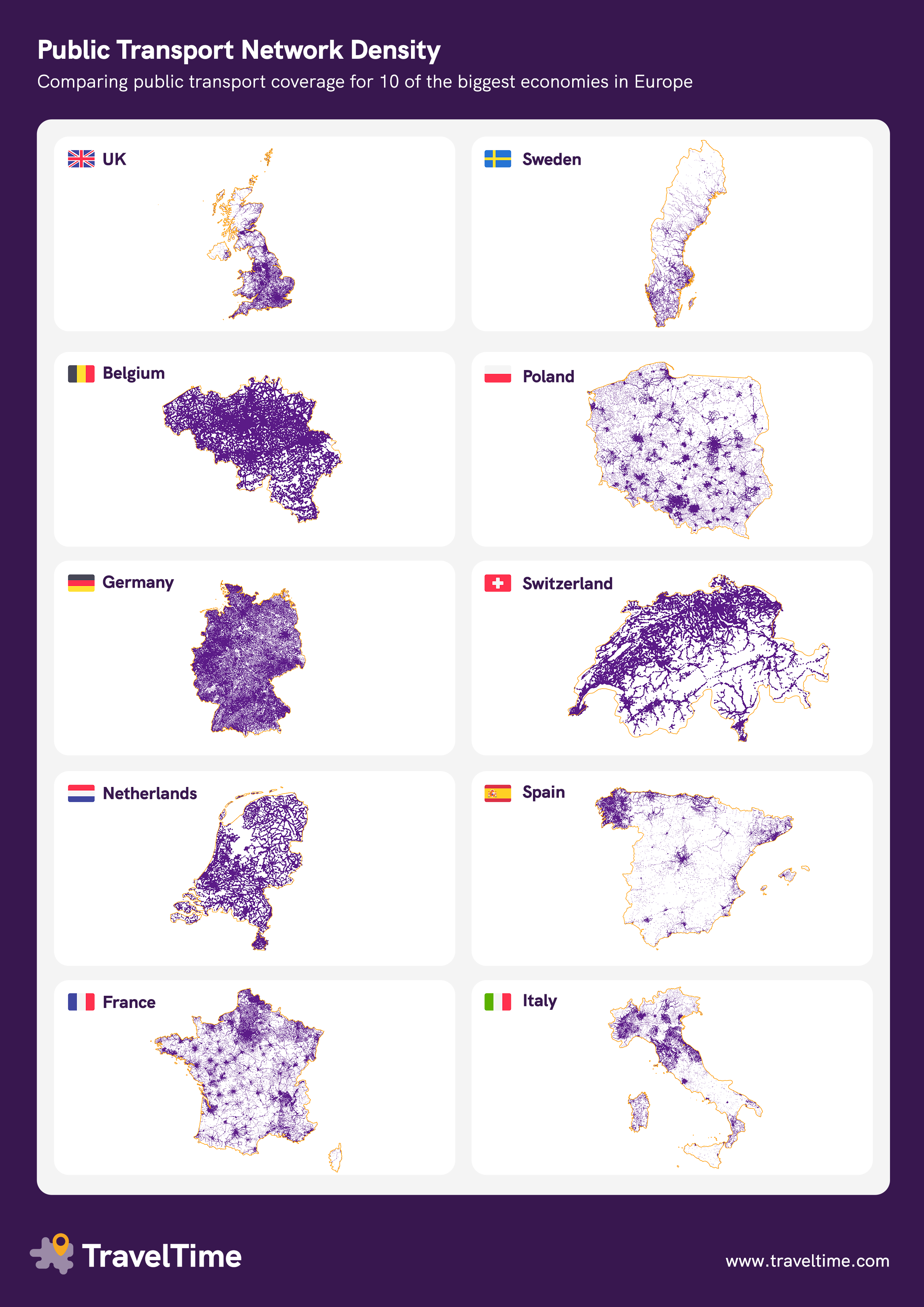
Visualising which areas of the country are reachable by public transport. Maps with higher concentrations of purple show higher public transport connectivity.
How we built the maps:
I don't think the database is accurate and complete.
Especially in Italy the region disparities (that certainly exist) seem much too strong. For instance im pretty sure there is more public trnasport around Naples in campania.
Agreed. The Italian region with the (relatively) worst public transports is Sardinia. Which seem fairly represented on that map. Everything else should show more connections.
The database does include Campania transport networks. The reason it looks so different is because of transport density - whilst there are transport routes in this area, it's not dense. In the visualisation each stop only has a 15 minute walking catchment area around it, so if the stops are few and far between, at the zoom level it won't show a lot of coverage. You can see when you open up the map in more detail here that there are routes in the area.
But for example the Sorrento peninsula is almost empty, despite the fact that it has a dense public transport network.
Thanks. I'll have our data team look into it but most likely if they're spaced out, once we zoomed it out and exported at a country level it wasn't too visible.
You can clearly see the boundaries between different public transport operators, which means different GTFS providers. I work in the field and for the area in my agency, I can clearly see on your map the networks for which we provide GTFS as open data and the ones we don't. But it is also clear in other areas of Italy just looking at the map.
No, the data is just extremely incomplete. Just taking a very quick glance, without comparing with other maps, I can tell you're missing railway stations along several railway lines in southern Italy, for instance to the Gargano peninsula, along the coast west of Taranto and in various places in Sicily (Pozzallo, Licata, Termini Imerese etc.). This is just off the top of my head and sticking to railways; I'm sure there's thousands of bus stops missing, too, but I don't know by heart where bus stops are.
Do you also have data for Austria?
What programs do you use?
This is fascinating. Thank you for creating it! I know the Europeans have some issues with the data but as an American this makes me very jealous. (And would be quite sad to be the American version.)
Hmm and now are large bodies of water handled? Doesn't seem like they're handled very well, eg Sweden and Switzerland are full of lakes that on your map look like undeserved areas
Just want to check I'm answering correctly, what do you mean as underserved? As the maps were created by pinpointing where public transport stops are, and a surrounding 15 min walking area, locations where there's large bodies of water would not be coloured purple as there's no station.
I understand what you did but I think large bodies of water should have a separate colour. Otherwise the interpretation of your map is that there's no transport on lake Zürich because the government can't be bothered to put public transport there, rather than.. It's a lake
Same as for mountains. You just need to be carefull what information you deduce from this graphic. If you care about service quality, this is the wrong graphic to pick.
Yeha you make a good point but I mean... Isn't that the whole point of the graphic?
Not sure what exactly OP had in mind, but it certainly better illustrates structural differences between the countries, as well as oddities within the countries.
People already explained why Galicia in northwestern Spain looks so different (the settlements are smaller, making the population more spread out), but there are also details in other countries that make me curious. For example why Saxony has such a noticeably denser network than the rest of eastern Germany (with the exception of Berlin, of course).
There is actually public transport across the lake. And its included in the same standard ticket. That should really be on the map.
Yeah I know and it's great. I didn't want to get into that because OP didn't know/account for it
I think I have almost never used one, but I knew somebody who commuted to school across the lake.
As a German from the lower right corner I feel this is optimistic (yes there are routes but they are often serviced only once/twice a day).
Northeast Germany here, we have the same issue. Two busses a day is definitely standard in our rural areas, so it's not remotely as connected as it seems in this map.
And often only on shool days, especislly buses, so if your state has holidays, you don't have public transport
Mr. Fancypants can't make it work with a bus that picks him up at 9:47 and returns him home at 15:22? /s
The maps are extremely misleading. Belgium and Switzerland are just a fraction of Sweden or France, yet they appear to be bigger!! As a result, Sweden and France seem much denser than they really are.
Very interesting maps, thank you! I'm from Germany but never realised that we kinda are a bit privileged with the amount of public transport. We like to complain about it a lot. And I mean a lot. Not to say it's not necessary to complain but compared to other countries, I'm surprised!
It’d be interesting to see how these maps differed based on frequency of service
German and Belgium network are perfect
Italia is like : Let just build the north lol
While that might have been the national motto since italian unification, I think it's a problem of harvesting datas, for example I clearly see the bus lines in the Trentino province but in the Veneto region I can see them in the province of Verona and Venezia but in the other provinces just the railways. I guess because there is not a single central authority some do not publish datas online in the same way.
The Belgian one is wholly theoretical.
'One bus per day' boom it's on the map.
Would need to show service frequency somehow.
I understand that each public transport stop is represented as a dot. Would be interesting to see an enhanced version with a color coding for the frequency at which a means of transport departs from there.
[deleted]
Belgium is less than a quarter the land area of England.
This shows density, but with no regard for scale. Also no accounting for where people live - i.e. population distribution and density.
r/dataismisleading
I'll hold my hands up and say for the sake of the infographic we had to use different zoom levels, I'll make sure to do it better next time!
Just did a quick screenshot using the same zoom level on our internal tool if you'd like to compare Great Britain with Belgium if anyone's interested. As a whole, I'd still say Belgium's connectivity is better, but obviously it's a smaller country so will be easier to get full coverage.
Small note as a Belgian: yes we have good connectivity, but that costly affair is caused by the fact that our population is spread out over the country, as opposed to centralised in city/village centres.
Interesting number would be average walking time/distance it takes to reach a public transport stop.
Great Britain isn't England. England is about 60% of Great Britain, which includes Scotland and Wales.
As you can see on your Belgium "zoom," the entire country can fit centered on south and western England and be comparably dense. The Midlands are also moderately dense, while only northern England, Scotland, and Wales are truly sparse. Notably for Scotland, since I looked it up quickly, the population density is 1/15 that of Belgium on average. But it's all concentrated in the areas that are connected.
Just want to clarify why I used the term Great Britain - because the visual in the link doesn't include Northern Ireland.
I agree that Belgium's size makes it easier to have higher public transport density though!
As a Dutchie I'm pretty ashamed of our network, especially if you compare it to neighbouring Germany and Belgium. We have mostly the same city/countryside density and even more flatland to easily built.
And the US?
File not found.
We should try this next! We have an internal tool that maps our public transport providers in the US so thought I'd share the screenshot.
Spoiler: it's quite sparse!
State by state would be neat, comparing denser northeast states with fairly old villages everywhere to western states like California that don't have that sort of high rural density.
No no no, That’s just an empty map of the us!
Wait.
Yeah, that’s right.
[deleted]
UK & sweden: F* the north! Spain & Italy: F* the south!
Worth pointing out that England is a lot more densely populated than Scotland, and I'd imagine that Sweden is a similar story
Ofcourse it is just funny, when you look at the Netherlands and Belgium. The while country has a decent network, as it is a small country and also densely populated
North-western Scotland is weird, and I say that living there. We have some good rail routes, but there are limits. The existing lines usually use two carriages and aren't super frequent (and take a while, 5.5hrs from Glasgow to Mallaig on the West Highland line) and outside the height of summer its often very empty. Wonderful life line, but there are limits given our low population density spread amongst the mountains (plus there's a lot of public transport here that aren't trains, like the ferries that connect the islands and peninsula communities). It's odd. Probably could do with a line from Fort William to Inverness, but that's the only real demand left. Most of the people live on the east coast, which is served by Edinburgh-Dundee-Aberdeen-Inverness line, so it really just needs a line for people on the west coast to easily access the capital of the Highlands.
The Borders are also pretty sparse, again due to mountains and population, but you can see the Central Belt of Scotland and the major cities of Northern England have quite a lot of rail.
Not really a fair comparison, considering some of these countries are much larger than the others, and some of them have serious mountain ranges that prohibit the development.. of further networks.
For example, France is 18x larger than Belgium. Everything else being equal, you can't expect a larger country with more rural area to be as developed in public transportation networks as a smaller country.
This might be a little more useful if the countries were all at the same scale. Since all the scales here are different, it's much harder to visually compare network densities between nations.
Throw Canada in there. The map would be as white as the snow that covers the ground sometimes.
The gold borders are a mistake. It makes it looks like there’s additional information that isn’t there. A light gray or something like that would be better. Or even just nothing at all and letting the networks speak for themselves
This doesn’t really say a lot unless it factors in frequency somehow, maybe the line alpha is number of journeys per day or something. Not of people, I mean if availability. In the U.K. I can see lines in areas that the reality is there’s one a day, which is almost useless, yet this puts the route on a par with others that may have 2 an hour.
Who knew Galicia had such a robust public transportation network.
What's going on in Galicia that it's the only place in Spain with a network?
Galicia really sticks out when you look at Spain.
[removed]
[removed]
[removed]
Would also be interesting to see the public transport network in the capital/largest city in each of these countries.
That map of Spain is not accounting for a lot of train and bus lines.
[removed]
Spain looks like a dog with a little nose
Public transportation including buses and trams or only trains?
It would be so weird if there was a way to geographically represent countries together to the same scale and to their proper orientation to each other to see how these systems could operate together.
I can't tell if this is good or bad, you should have the US for reference so we know which one is the absolute worst
[removed]
First of all, can’t blanket all the pt together. Gotta be a way to show efficiency of the pt. Secondly, you can’t make Germany same size as Netherlands. Fit to scale
[deleted]
[removed]
[removed]
And can we see this same graph for the United States? Or even State by state?
Don't let density fool you, Belgium's network might be extensive but it's still miserable, especially TEC's (bus company operating the southern part of the country)
Ngl I thought that uk one was a new Pokémon before I read the title n sub name
Wenn das ein Wettbewerb wäre: Ich glaube wir haben gewonnen.
Can you please share the data?
[removed]
Do the united states next, i want to see how pathetic it is
I’m sorry but I’m crying laughing at Poland right now because all the stupid Polish jokes I’ve heard are suddenly making sense. Polands public transit is the only one that is all dots, no line interconnecting communities. The damn Pol’s missed the main purpose of public transportation, connect people!
[removed]
[removed]
I wanna see America just to see how much worse our transit system is
Spain. From Santander to Bilbao. 100 kms. 3 hours in train!!! 60 minutes in car. This is public transporte.
Well now we can clearly see why Christ stopped at Eboli
Yeah, I'm from Belgium. It ain't working !
Italy gives 0 fucks about the south. Nothing new.
Scale is a factor, too. Belgium looks darker than NL partly because the scale is smaller.
I do not understand what does dots mean:
>Visualising which areas of the country are reachable by public transport. Maps with higher concentrations of purple show higher public transport connectivity.
How we built the maps:
We used our own public transport database to identify the lat/long of each public transit stop
We drew a 15 minute walking catchment area around each stop to identify the other surrounding areas with easy access
So a bus stop is a dot? Or a train station of course. But then it depends in the frequency. Maybe Germany has thousands of bus stops that pass once a day but Spain has less bus routes but more frequency. Also frequency does not mean anything if the public transport is empty.
Comparing the density of public transport networds between different countries when they're NOT presented at the same scale isn't possible. In this map Switzerland and Germany are presented as being the same size, and with Switzerland having a lots less dense network.
But reality is that Germany is on the order of 9 times the area, so the density of the German network is only 1/9th of what it appears here, relative to Switzerland.
Does this include both bus and rail?
[removed]
Proving what I've realised in practice last week: Zeeland is by far the lest connected province in the Netherlands especially Zeews Vlaanderen.
Germany is German-Ly efficient
Yes, but as a Swiss, there is a stark difference in availability. In villages that only have a bus as public transport, it can go from every 10-20 minutes to every 2 hours real quick. A few more remote villages only a bus 2-4 times a day during school holidays.
Where are the train lines going from north to south Italy? Not public!?
Why list something that could be a map?
I bet the USA map is just.... non existent or really bad quality
Don't be fooled by the UK, public transport in the UK is awful.
Italy is interesting, we can see difference between rich north and poor south of country
Data are not good for Italy, all of the north should look like Piedmont, can't say specifically for the south but it definitely would look much better than depicted here
there must be inconcistency between data. In some provinces they didn't harvested datas for busses like in some others.
Compare these maps with population density. For example Italy vs France (here. If we consider infrastructures, the South of Italy compares better with Africa than with Europe. And someone is considering to build a bridge between Calabria and Sicilia on Stretto di Messina. We will have a beautiful cathedral in the fucking desert.
lizufyr t1_jdvxj0d wrote
It would be interesting to correlate this with population density. Like, Spain looks pretty empty until you realise that the population is actually focused mostly around few big cities, while Germany had lots of villages and small towns throughout its area.