Submitted by TheMapStack t3_yxu07h in dataisbeautiful
Submitted by TheMapStack t3_yxu07h in dataisbeautiful
Ya I thought it was weird, but I'm not a demographer working for the census. I just use what they give me.
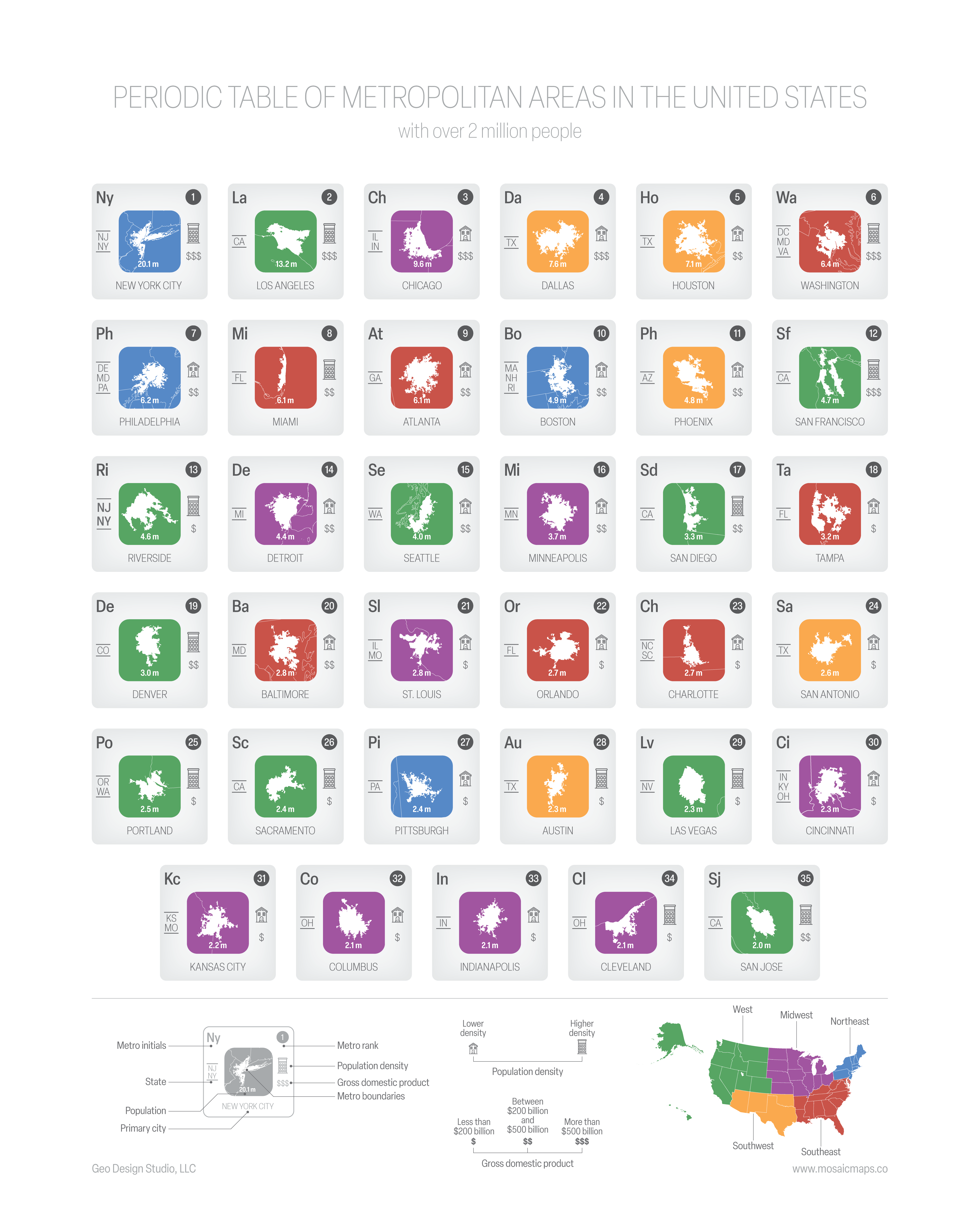
I was inspired by some other periodic table-style data visualizations and made one for US metro areas. Enjoy!
Data: Metro area boundaries come from TIGER, population data comes from census.gov, and the regions comes from the National Geographic Society.
Tools used: ArcGIS, Adobe Illustrator
Find me at https://geographybygeoff.substack.com/ if you're interested in finding more stuff by me.
One guy who lives in Rhode Island: "I'm in Boston!"
Raleigh/Durham is 2.1 million but some dumb reason the metro area was split up into two when it still functions as a single metro area as the job center is right in the middle.
[removed]
I kind of wish the data for density and GDP was higher resolution.
Riverside is CA, I assume, not NY, NJ?
Farts! Yes, California. Thanks for pointing that out.
Nice, but I can tell you that people commute to NYC from further away than what is shown. I know people that commute from Eastern PA / Western NJ as well as further south in NJ.
I like the idea, but the two letter name (like an element) seems arbitrary and confusing. The Minneapolis area would better be defined by MSP, which is both the airport code and a reference to Minneapolis and St Paul. No one here would ever refer to the area as Mi.
Tc should be the 2 letter abbreviation, IMO, just like Au is for gold the letters don't have to be the first two letters. Mi = Michigan
Separating San Jose from San Francisco doesn't track well with everyday life in the area. It's definitely one metro area. If San Jose is separate, why not also Oakland?
Smaller scale, but Cleveland gets shafted a bit too. I can agree a bit with Akron being its own area, but not Lorain/Elyria, that’s clearly an extension of Cleveland
The bay area has 2 metro areas SF-Oakland-Berekely and SJ-Sunnyvale-SC, but I never understood why b/c I know many people that live in these places, but commute to the other metro areas aka just combine the bay area metro as a whole don't separate it
and why did you follow the census regions to a t except for the south west? also per metropolitan areas are you using metropolitan statistical area
the population density on san diego seems off, I don't think san diego has a higher density that e.g. chicago
It would be cool to see this for China with a higher population cutoff. Is something similar already out there?
I haven't found anything else for cities, etc. I've seen similar things for like mountain ranges though which is where I originally got my inspiration. I really enjoyed pulling this one together to I already planned on making a city version for the US and Europe, state version for the US, and other variations. It's a lot of work though so they're slow coming. Fun visualization when it all comes together though.
averagecrazyliberal t1_iwqjl1i wrote
Love the viz, OP!
But on what planet does the data source (you mention TIGER) justify including Westchester County, what seems like a third of the state of New Jersey but none of Connecticut (particularly Fairfield County) in the NYC data. Lol