Comments
DMala t1_j6d28yc wrote
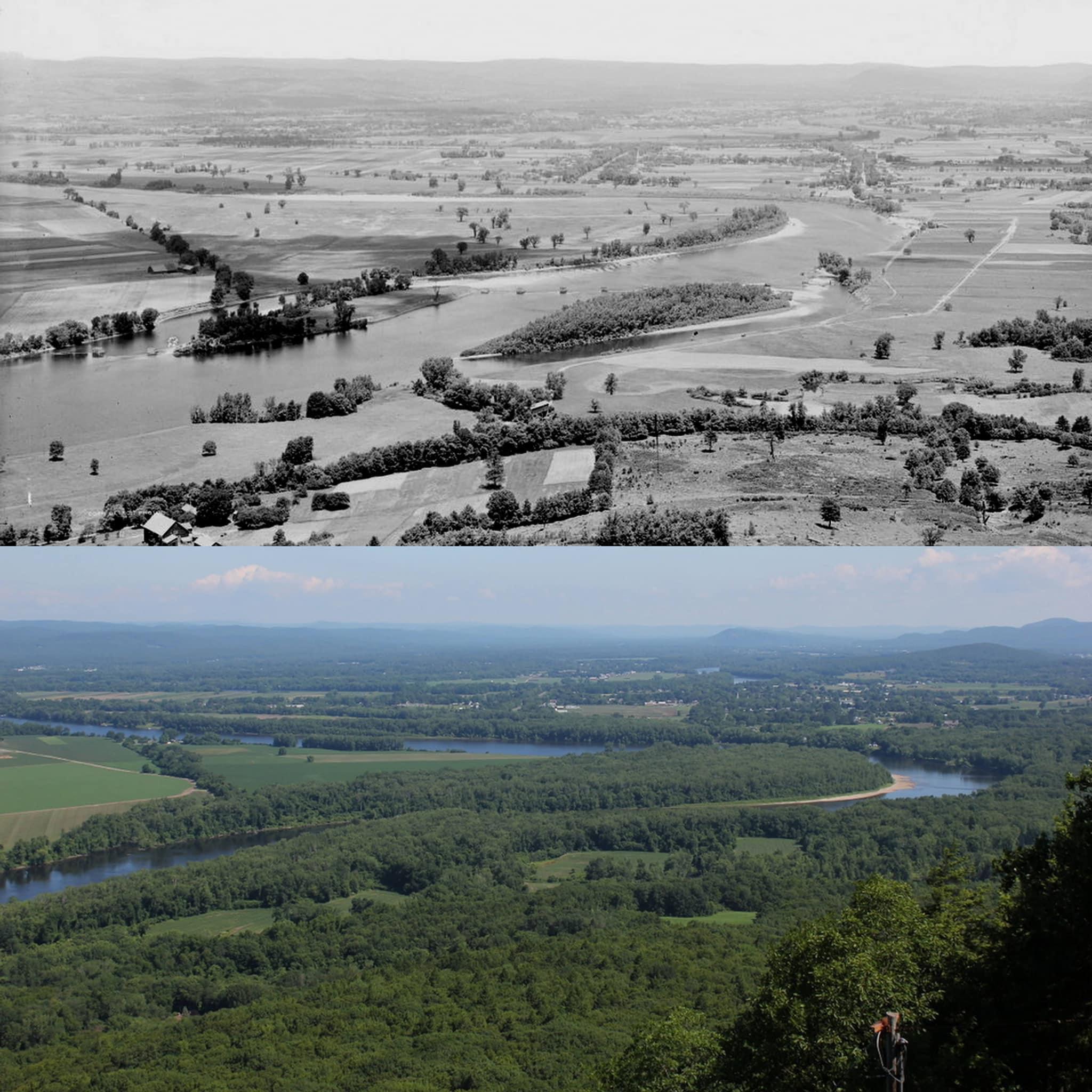
It blows me away to see stone walls running through the woods and realize how much of it is less than 120 years old or so.
BrokedownAlice69 t1_j6d31f3 wrote
Gets me every time. I treated them like they were just no thing growing up. Then when I realized how ancient some of them were…
rexskimmer t1_j6d73dt wrote
We're actually going through a second phase of deforestation. Woodlands have been declining since the 80s due to development.
PabloX68 t1_j6fa5k7 wrote
Not true.
https://www.fs.usda.gov/nrs/pubs/ru/ru_fs161.pdf
If you actually look at the studies, the total biomass of trees in MA is increasing and the removal of live trees is going down.
I've lived in this state long enough to have seen many areas go from clearcut farmland to more wooded. Additionally, tree growth is many suburban neighborhoods is substantial.
rexskimmer t1_j6huab7 wrote
Increase biomass means younger 100-year forests are maturing, but there's still a decrease in acreage (even if only slightly in the last decade or so). We've seen a larger decrease in forest area since the 60s.
https://harvardforest1.fas.harvard.edu/exist/apps/datasets/showData.html?id=hf013
https://www.fs.usda.gov/ne/newtown_square/publications/other_publishers/OCR/ne_2003_brooks001.pdf
OldWrangler9033 t1_j6dp7k0 wrote
Unfortunately, the Farm Lands from the 1900 would have been taken from out by housing development as well. Just too much demand.
3720-To-One t1_j6cybf5 wrote
Makes me miss the pioneer valley
PhiloBlackCardinal t1_j6d1b23 wrote
I was scared we'd see the inverse, this is beautiful
JaKr8 t1_j6d3dlx wrote
Suddenly this old talking heads song popped into my head...
This used to be real estate Now it's only fields and trees
Where, where is the town Now, it's nothing but flowers
Thankfully there are still so many bucolic vistas in western Mass. My favorite is still Tyringham cobble.
BrokedownAlice69 t1_j6d2yi5 wrote
It’s insane how well all those trees around the river grew back in!! Those were natural to the area until they were forested right? Nice to a picture of nature recovering in todays world
Crazyhellga t1_j6dev9v wrote
Highly unlikely to be the same species. Reforestation, unless very specifically and actively managed, is “junk trees” first and it will take a few centuries to become and “old growth” forest. Still won’t be exactly the same as “before” - a different mix of animals is living there now and different environment surrounds it and there are all kinds of introduced plant species, etc. though constant change is the only constant in nature. After all, 17,000 years ago this area was just a solid sheet of ice.
Giving_Cat t1_j6dj1fs wrote
Certainly no Elm nor Chestnut in the second picture.
VulcanTrekkie45 t1_j6dpowv wrote
Looks like the river has shifted course slightly
jwas1256 t1_j6fl42b wrote
was talking about this in my botany class this past week. the berkshires and CRV are only very recently forested. all these mountains and hills were completely bare until the early 1900s. when colonizers first came they were under the impression that it was all fresh usable farmland. they found very quickly that is was about a foot of soil(if that) and then many, very large rocks and boulders (hence the large quantity of stonewalls in the woods). so after trying to convert the area into usable farmland for crops and realizing this someone recognized that the midwest was much suitable land for crops. we were then left with no trees until people realized that we need to replace the trees.
PabloX68 t1_j6faqlr wrote
For anyone looking at this pic and commenting on the tree growth, go walk through Minuteman NHP in Concord, then go drive around the surrounding residential areas. Minuteman NHP was clearcut to make it look like it was in 1775. Before that park was built, there were residential neighborhoods with trees growing between the houses. The rest of suburban MA still has those trees and they keep growing.
There is more total tree biomass in Massachusetts now than 50 years ago.
The_Pip t1_j6d7kj2 wrote
There is some nice reforestation going on there.
Slight-Possession-61 t1_j6e42oc wrote
Is that the famous Ox Bow?
I know it’s around there…
UniWheel t1_j6ee3ow wrote
>Is that the famous Ox Bow?
No. More exactly, it is "an" oxbow, but not "the" oxbow of the area.
In the right kind of soil situations rivers do this - once there's the slightest hint of a bend (and when isn't there?), the water at the outside has to flow faster and so scours more and increases the bend creating a "meander" which can eventually become an "oxbow".
"the" oxbow was like this, but one day in 1840 with people watching the river cut right through the narrow part forming a new channel. Today that oxbow is only really connected at the southern end and is essentially a lake rather than part of the river, and so not an oxbow. (the several times diverted Mill River does drain into it though)
Left to its own devices this one would eventually do that too; though it may not be left to its own devices. If you look at the area overall, Mount Tom, Mount Holyoke, Sugarloaf, Mount Warner and Mount Toby etc are confining. But where exactly the river cuts through all that rich silty floodplain farmland has been variable over geological and even historic time.
richg0404 t1_j6f0jmc wrote
I've lived in New England all of my life. I love seeing old pictures from the area and am always amazed how much land was clear cut 100 years ago.
Current-Photo2857 t1_j6gitik wrote
Forests grow back more quickly than people realize.
There’s an interesting theory regarding when European colonists arrived in the Americas and brought the diseases that killed off many Native Americans.
The theory is that the Native Americans had cleared a great deal of farmland and when many of them died from those European diseases, all the trees grew back & the forests reclaimed their farmland and absorbed so much carbon dioxide that it caused global cooling and the “Little Ice Age” of the 1600s.
This-Recording9461 t1_j6gksri wrote
The oxbow, correct?
https://en.m.wikipedia.org/wiki/The_Oxbow
Also featured by photographer Joel Sternfeld in The Oxbow Archive.
WikiSummarizerBot t1_j6gku1i wrote
>View from Mount Holyoke, Northampton, Massachusetts, after a Thunderstorm, commonly known as The Oxbow, is a seminal landscape painting by Thomas Cole, founder of the Hudson River School. The painting depicts a Romantic panorama of the Connecticut River Valley just after a thunderstorm. It has been interpreted as a confrontation between wilderness and civilization.
^([ )^(F.A.Q)^( | )^(Opt Out)^( | )^(Opt Out Of Subreddit)^( | )^(GitHub)^( ] Downvote to remove | v1.5)
ceaselesslyintopast t1_j6inss5 wrote
The Oxbow is the view looking to the west from the top of the mountain. This is looking north.
This-Recording9461 t1_j6ipgb5 wrote
Thank you for the clarification, I totally missed it!
[deleted] t1_j6d76gv wrote
[deleted]
NativeMasshole t1_j6d8d2c wrote
That's just not true. Native Americans did manage the forsests to a great degree, but it wasn't until the 19th century that the landscape became mostly open farmland.
madtho t1_j6e94ui wrote
Sinton, the author of that article, has an amazing book called From Devil’s Den to Livkingwater. It’s about the Mill River in Northampton, but is really a history of the whole region. Incredible book and a must read for any Pioneer Valley resident.
A_Man_Who_Writes t1_j6cusns wrote
Always refreshing to see reforestation instead of deforestation.