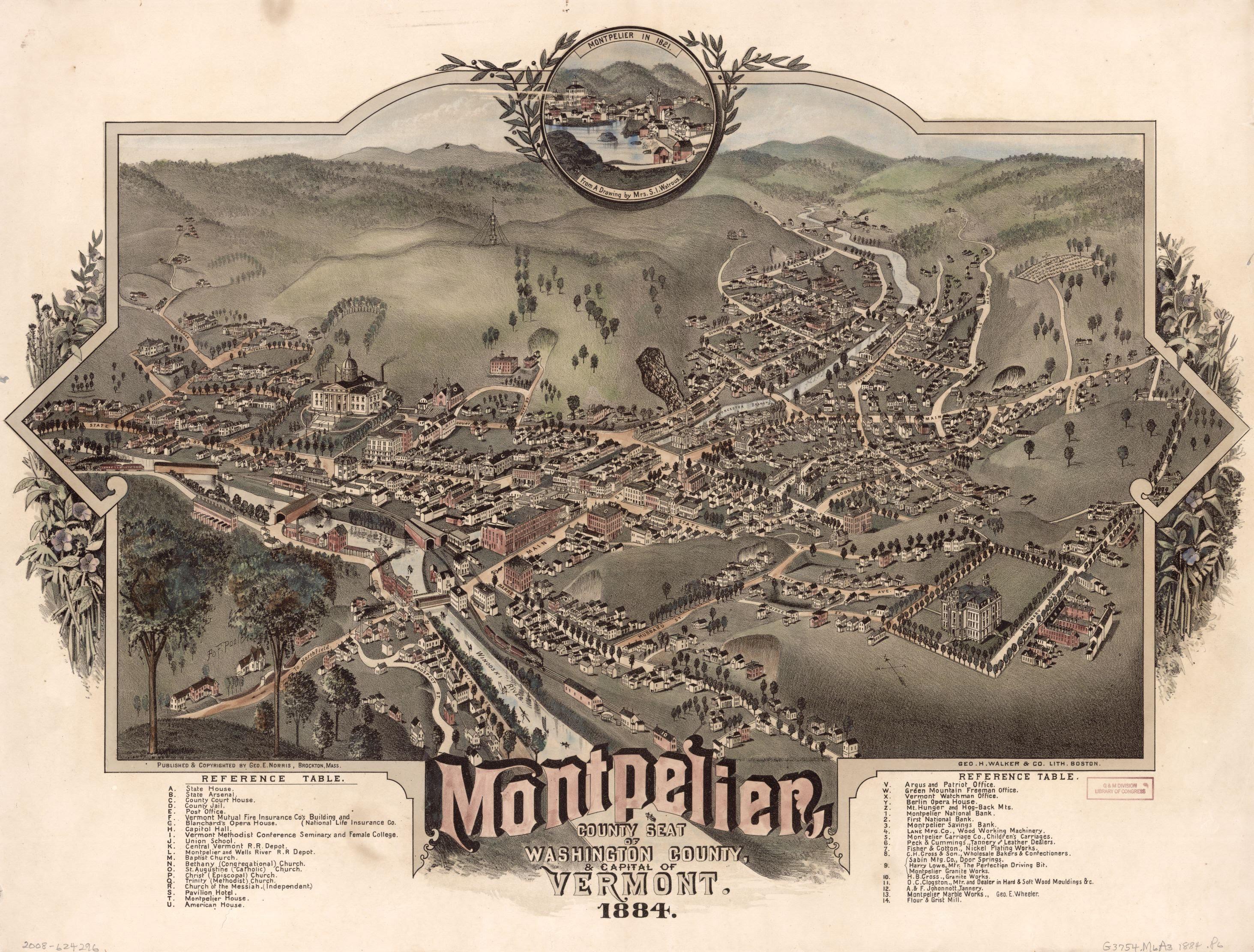
Submitted by MisterMcFlyXXVI t3_z1s6tb in vermont
Comments
whaletacochamp t1_ixd5exu wrote
It’s almost like it’s the same town with most of the same buildings!
Not to be an ass…but…how would the layout be any different now?
MisterMcFlyXXVI OP t1_ixdcjih wrote
This map was 140 years ago. So many cities look entirely different than they did then. Though I grew up in Vermont I lived the last 9 years in Richmond Virginia which is virtually unrecognizable compared to 1884.
whaletacochamp t1_ixdgv4a wrote
Fair point. But with a rural city like Montpelier I don’t expect the large changes that many other large cities would see. Even a lot of old northeast cities like Boston and Montreal have sections that are largely unchanged minus what’s been added around it.
Montpelier is also a city that is very much built around its natural landmarks. So things tend to stay where they are because there’s no better place for them.
VanBanSargent t1_ixftqv3 wrote
I grew up in Richmond , Va and now live in Vermont ! Fun times ..
MisterMcFlyXXVI OP t1_ixg4a63 wrote
No kidding! Funny how life works that way 😂
Loudergood t1_ixdrqli wrote
Not for lack of trying by the river..
Hell_Camino t1_ixep4yo wrote
I live in Montpelier in a neighborhood off Terrace Street (upper left corner of the map) that was developed in the 50s and 60s. It’s not even on the map as anything other than woods.
And the tower of Hubbard Park isn’t on the map; which is a local landmark.
So, lots of changes are possible over that time.
mountainofclay t1_ixey075 wrote
There is a tower farther back though. I wonder what that was?
Hell_Camino t1_ixfahi1 wrote
Perhaps that was a predecessor to the current tower
mountainofclay t1_ixid1e0 wrote
Do you think the tower in the map is the same location as the current tower or is it farther back?
MisterMcFlyXXVI OP t1_ixcxe3f wrote
Right? Super similar
21stCenturyJanes t1_ixcqmqg wrote
Looks very similar to today. Montpelier has been managing to block development for over 100 years!
MisterMcFlyXXVI OP t1_ixcxd09 wrote
Absolutely! I was surprised at how similar it is
zkentvt t1_ixd8etd wrote
I can see my old house from here!
dropkickninja t1_ixcpf8q wrote
this is pretty cool.
MisterMcFlyXXVI OP t1_ixcxdi3 wrote
Yeah I think so!
advamputee t1_ixd4rr9 wrote
I saw a similar one in a cafe yesterday of White River Junction!
whaletacochamp t1_ixd5czu wrote
God I love illustrative maps. Keep ‘em coming OP
ANTI-PUGSLY t1_ixe0vne wrote
/r/papertowns
Vermonter_Here t1_ixdc19f wrote
I count six covered bridges!
The sixth is a bit less obvious; see if you can find it. :)
Also, really interesting to see how Hubbard Park hill was almost completely treeless! Here are some more photos showing what that looked like, including an aerial photo from 1927.
Jumpy_Platform_1610 t1_ixdsq4a wrote
I saw this and had to find one to buy for my Montpelier native husband for Christmas!
[deleted] t1_ixetaew wrote
[deleted]
[deleted] t1_ixewb67 wrote
There’s a copy of this in Capitol grounds
VanBanSargent t1_ixfuan8 wrote
I can see my house ! It was built in 1880. The illustration doesn't really look like it but there is a building where my house is.
BeckyKleitz t1_ixdcza1 wrote
All those covered bridges!!!
mycophdstudent t1_ixe57sc wrote
Shows how heavily deforested Vermont was 140 years ago compared to now.
Intelligent-Hunt7557 t1_ixfhvvx wrote
I assume you know why but for others: wool >>> milk back then, which prioritizes cleared land…
ABadMagician t1_ixd675r wrote
Beautiful
varadins t1_ixet71i wrote
Thanks for sharing this!
_crAss_ t1_ixfwc6s wrote
The Main St bridge/ Berlin St intersection and gateway looks way more interesting from back then instead of the gas station and supermarket parking lot of today.
dcarsonturner t1_ixfyom8 wrote
Neat!
AutoRot t1_ixg3p1v wrote
No Langdon street. That’s the only major addition to the downtown core I can see here. I wonder why it was added
FRANPW1 t1_ixkz61b wrote
Still looks the same.

ChefPneuma t1_ixcumzm wrote
Really cool
It’s so similar to todays layout